|
NATIONAL FLAG, NATIONAL EMBLEM, NATIONAL CAPITAL, NATIONAL ANTHEM|ADMINISTRATIVE DIVISION GEOGRAPHICAL FEATURES|NATURAL RESOURCES|CLIMATE|POPULATION, ETHNIC GROUPS |
|
|
Summary |
|
|
|
The People’s Republic of
China is situated in the eastern part of the Asian continent on the western
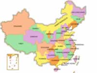
coast of t According to the Constitution, the administrative divisions of China is as follows: 1) The country is divided into provinces, autonomous regions and municipalities directly under the Central Government; 2) Provinces and autonomous regions are divided into prefectures, autonomous prefectures, counties, autonomous counties and cities; and 3) Counties, autonomous counties and cities are divided into townships, ethnic townships, and towns. All autonomous regions, autonomous prefectures and autonomous counties are ethnic autonomous areas. The State establishes special administrative regions as it sees necessary. At present, there are four municipalities directly under the Central Government, 23 provinces, five autonomous regions and two special administrative regions. |
|
||||