Chinese 'rainbow' UAV takes geophysical job
- By Chen Boyuan
 0 Comment(s)
 Print
Print E-mail China.org.cn, October 22, 2015


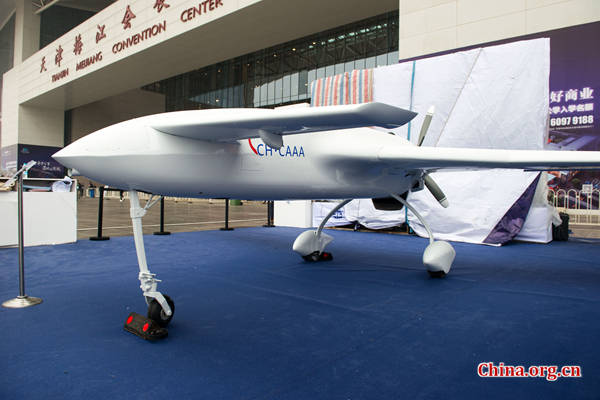
A Caihong-3 (CH-3, also known as Rainbow-3) unmanned aerial vehicle (UAV) was displayed at the 2015 China Mining Congress and Expo held in Tianjin on Wednesday. This aircraft is the civilian version of the CH-3 used as part of the system for comprehensive geophysical measurements and geological exploration.
 |
|
A CH-3 UAV on display at the 2015 China Mining Congress and Expo held in Tianjin on Wednesday. [Photo by Chen Boyuan / China.org.cn] |
The CH-3's appearance in Tianjin gave the public its first view of this once-mysterious UAV, capable of multitasks, depending on its payload, and also marked the start of commercial services after two years of test flights and production refinements.
The CH-3 carries two special modules, one on each wing tip, and a third one in the fuselage belly. In these modules, the magnetic field detectors and radioactivity detectors are capable of detecting "geomagnetic anomalies" that can be the result of mineral resources hidden beneath the earth surface, according to Liu Kai, chief designer of the CH-3.
UAV-based exploration has been extensively tested in scale operations in Nenjiang of Heilongjiang Province, as well as Karamay and Kashi of Xinjiang. This CH-3 version has completed up to 40,000-KM effective inline missions, including those conducted deep in the night, according to China Academy of Aerospace Aerodynamics (CAAA) of China Aerospace Science and Technology Corporation (CASC) and China Geological Survey Bureau (CGS), the system's joint producers.
This CH-3-based system of geological survey and mineral exploration is the first of its kind in the world. It features higher safety, quality, efficiency, and intelligence compared with manned aerial geophysical measurements, and far exceeded anything conducted by land vehicles.
"The CH-3 system's debut at an international mining expo is an example of how we can put military UAVs into civilian uses. It has significant implications for the merger of military and civilian industries, apart from promoting UAV-based geological exploration in the world," said Shi Wen, chief engineer of the CAAA Caihong UAV Series.
He also explained that cost-efficiency was the reason why the CH-3 currently uses old technology of a piston engine instead of a turboprop engine, or even turbofan engine, that would allow higher speed.
"Using a turboprop on CH-3 and other Caihong UAVs may cost twice as much, but its overall efficiency does not increase in proportion. In other words, I spent half the price but achieved 70 percent of what a turboprop engine can do," said Shi.
He added that in geophysical measurements, lower-speed UAVs actually work better. "CH-3 adopts the canard layout because it helps reduce the stall speed; meaning it can fly even slower," he said.


Go to Forum >>0 Comment(s)