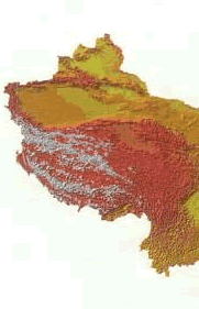
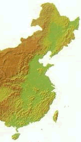
Topography
China’s
topography is varied and complicated, with towering mountains, basins
of different sizes, undulating plateaus and hills, and flat and
fertile plains.
A
bird’s-eye view of China would indicate that China’s terrain descends in four steps from west to east.
The
top of this four-step “staircase” is the Qinghai-Tibet Plateau.
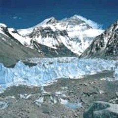
Averaging more than 4,000 m above sea level, it is often called
the “roof of the world.” Rising 8,848 m above sea level is Mt. Qomolangma,
the world’s highest peak and the main peak of the Himalayas.
The
second step includes the Inner Mongolia, Loess and Yunnan-Guizhou
plateaus, and the Tarim, Junggar and Sichuan basins, with an average
elevation of between 1,000 m and 2,000 m.
The
third step, about 500-1,000 m in elevation, begins at a line drawn
around the Greater Hinggan, Taihang, Wushan and Xuefeng mountain
ranges and extends eastward to the coast. Here, from north to south,
are the Northeast Plain, the North China Plain and the Middle-Lower
Yangtze Plain. Interspersed amongst the plains are hills and foothills.
To
the east, the land extends out into the ocean, in a continental
shelf, the fourth step of the staircase. The water here is less
than 200 m deep.
The
Topographical Map of China