| Home | Tools: Save | Print | E-mail | Most Read |
| Part 3 |
| Adjust font size: |
Beautiful Basum Tso Generally speaking, bamboo is a plant indicator of the southern We drove eastwards along the Faced with such a special sight, we all rushed for our cameras. As tall trees were obscuring our view of the Ba River, we had to make our way through them to the cliff overlooking the river. Looking down, we trembled with fear; the river was some 60 meters below. The branches of the trees were still stopping us getting good shots of the river; to get a full view, one had to go down out of the trees for a little way. One daring team member, holding on to branches as he went, carefully edged down a few steps to a slope, where, lying on his side, he took some shots of the river. With its wide rushing streams and luxuriant vegetation, the Ba River valley was a most beautiful place. But there was another aspect. At the densely wooded mountain foot were several square stone blockhouses, each about Basum Tso is also called The Basum Tso lies 90 kilometers west of There is an island in the lake, like a piece of green jade on the water. On the island amongst some trees stands the Tsozong (meaning ‘castle in a lake’) Monastery. The monastery at once seized our interest and we rushed to the lakeside. We found that the island did have a ferry and a boatman and we called to the boatman, asking him to take us across. The boatman came to us. He was about 60, his old age and difficult life clear from the wrinkles on his forehead. He was called Sampo and had originally lived some 30 kilometers from here but had come to the monastery for help after his wife died. He had lived here ever since and rowed the ferry on the lake. In fact he did not row but moved the ferry by holding with both hands a steel cable between the island and the lake shore. The ferry was tied to the cable with a rope, one end tied to the ferry the other to a wooden loop that hung on the cable. Thus, with both hands grabbing the cable, Sampo moved the ferryboat to the island. The waters were so clear that you could see the pebbles some two meters below. What a pleasure it would have been to take a boat, looking at the fish in the water and the trees on the mountains around the lake. But we had to give up the idea because we could not find a boatman to row us. The Tsozong monastery belongs to the Yellow Hat sect of Tibetan Buddhism and was built in the 17th century. In front of the monastery is a vacant yard as large as two basketball courts, empty apart from a river deer with an injured leg wandering about it. On the left was an old tree. The strange thing about it was that a young tree was growing out of the trunk of the old one and the phenomenon of two trees growing from a single body caused people to worship it as divine and festoon it with colorful flags. Beside the tree was a building, in which was a giant prayer-wheel, a meter in diameter and six meters high; it was made with ox-hide and painted with scriptures. Wooden sticks stuck out from the prayer-wheel, allowing worshippers to turn it. After returning from the island, I walked by the lake and found several big stones, each as big as a desk, carved with Buddhist scriptures. When it was time for our noon rest, I walked away with my camera along a road heading west, wanting to find more scenic spots in the Basum Tso area. Cliffs and green trees lined both sides of the road. The scent of rotting leaves from the primal forest met my nostrils. The calls of nameless wild birds and beasts met my ears. When I had walked about 300 meters I shivered, afraid of meeting a black bear or wild boar. Fortunately, just then, I saw a mantra and Buddha images carved on a cliff by the roadside, and immediately stopped feeling so edgy. Looking into the distance I could see a burnt forest where the undergrowth and bushes were all burned out and the earth visible. Only a few trunks, blackened by the fire, remained standing, like surviving heroes looking down upon a disaster. Near to the lake I saw pine-vines hanging densely on pine branches, their light-brown color masking the green of the trees. A one-hour walk brought home to me how the vapor passing through the Yarlung Tsangpo Great Canyon was transformed into these mirror-like lakes and how it nourished the forests and bushes on the mountains. Jomolangma Sacred Tea and Yi'ong
Yi’ong, a township in After crossing the At Yi’ong we saw orderly rows of brick houses with tiled roofs; with their high rising ridges, they looked quite a considerable size. What is the reason for such large houses here in Yi’ong, far off the Sichuan-Tibet highway? We were told that the Communist Party School of Tibet Autonomous Region had once been in Yi’ong. It was said that the government of Tibet Autonomous Region had also intended moving its office to Yi’ong, because its lower altitude, warmer climate, and plentiful vegetation provided a good place to live and work, not only for Tibetan cadres but also for cadres from other parts of China, who would not suffer from high altitude reaction here. After the Far to the east stand snow-capped mountains. The hillsides are clad with deep green trees. Crops of golden rapeseed cloak the fields at the foot of the mountains. By the side of the fields is a tea plantation, criss-crossed with field ridges. The tea bushes were green with luxuriant foliage and girls were busy collecting tea-leaves there. Standing by the plantation, we could hear their ringing voices wafted over by the wind from the mountains. I could find no difference between this plantation in Yi’ong and those south of the “Yi’ong tea is called ‘Jomolangma Sacred Tea’. Yi’ong is located at 30o.N, the same latitude as the famous tea-growing areas further east in China - Hangzhou, Dongting, Lushan, Taiping, Tunxi, Qionglai and also Qimen, where the best black tea comes from. This latitude is a magic one so far as tea is concerned. “Jomolangma Sacred Tea grows by Yi’ong Lake in the eastern “As to when, where and from what kind of tea tree Jomolangma Sacred Tea originated, according to Tibetan oral tradition, the tea began to be cultivated here when Chinese princess Wencheng came here to be married to the Tibetan king Songtsen Gampo in the 10th year of Zhenguan reign period of the Tang Dynasty (641), bringing with her tea seeds and talented workers.” Tea bushes have always been one of southern Although the Yi’ong tea plantation made me happy, the present state of Yi’ong Lake caused me great concern. Standing on an upland section of the plantation, I saw a stretch of open space before me. This was Yi’ong lake, but it has dried out and become a white sandy wasteland with a small number of waterlogged depressions. According to relevant historical documents, Yi’ong was an outlet lake. It was then 17 kilometers long and 1.3 kilometers wide, covering an area of 22 square kilometers, lying at an elevation of 2,200-2,220 meters and looking like a river course. But the present Yi’ong Lake in front of me looked very different. About ten years before scientists Gao Dengyi and Wang Wei had made meteorological observations at Tongmey and Yi’ong as part of their study of vapor flow through the Historical data show that Yi’ong Lake was formed some 100 years ago by a mud-stone flow, which blocked downstream rivers. One evening in 1897 there was a great mud-slide disaster, the flow blocking rivers, destroying villages and killing many people. Only three child cowherds escaped. They were on the hillside, intending to spend the night there, and thus witnessed the catastrophe. The mud-stone flow formed Yi’ong Lake. With natural conditions deteriorating, the lake is now dying out. Yi’ong Why could the beautiful Yi’ong Lake not last forever? The reason is that the lake bed is located in the wide river valley, one formed by glaciations. This results in a slow water flow and rapidly increased silt in the lake. In the upper reaches, the mud and sand brought down to the lake have formed chains of islets. In the dry season, the present Yi’ong Lake is no longer a lake at all. Only in the rainy season does the lake have a certain amount of water. Furthermore, the well-known Lop Nor Lake in Xinjiang has already disappeared from the earth and the The Yi’ong tea plantations are irrigated by water from Yi’ong Lake. If the lake disappears some day, the tea plantations cannot survive. We hope that day will never come. Yi’ong is deep in the A ceremony was held at
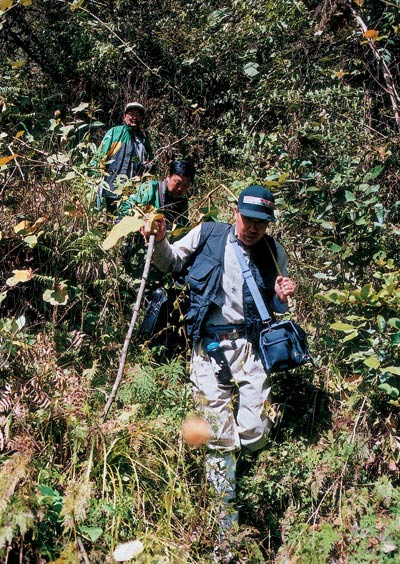
The author exploring in the Yarlung Tsangpo Great Canyon
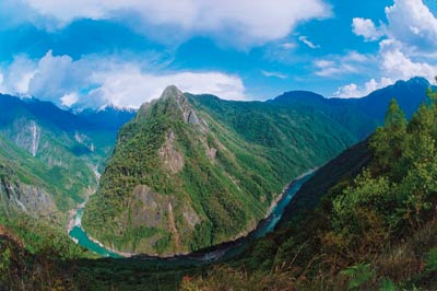
The magnificent Yarlung Tsangpo Great Canyon |
| Tools: Save | Print | E-mail | Most Read |
 |
| Related Stories |