| Tools: Save | Print | E-mail | Most Read |
| Take a Peak |
| Adjust font size: |
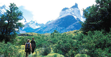
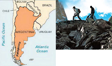
"They've got babies," I exclaim. "Six, maybe seven of them." We're on the first day of our month-long drive around Patagonia, the vast region at the southern end of South America that spans It's 8 pm when we enter Torres del Paine National Park, our first day's destination, and we still have three hours of daylight. We stop to watch a guanaco, a llama-like relative of the camel, roll in the dirt not more than 20 feet (6 meters) from us; we stop again at a small lake to admire two black-necked swans and six Chilean flamingos. We crest a rise and stop again, this time for our first close look at the granite towers of Paine.
"There's a williwaw," I say, pointing across the lake to a powerful squall blowing spray at least 50 feet (about 16 meters) into the air. Patagonia is famous for wind, westerlies that charge unabated across the southern Pacific Ocean until they slam into the jagged spine of the Next day, with about 40 co-passengers - backpackers, mostly in their 20s - we cross the lake on a catamaran to a campground, where we set up our tents. The kids and I make a 10-mile (about 16 kilometers) round-trip hike. The skies are clear and the wind moderate, gusting to only 30 miles (48 kilometers) an hour. For views this trail is as good as they've seen: tusks of gray granite 10,000 feet (3,125 meters) high; glaciers with walls of cleaving seracs; two backdrop lakes, one azure and one turquoise. In addition to the Torres del Paine, a visitor wanting to sample the best of Patagonia has to visit We cross the border into Braving gusts and choppy terrain, hikers press on toward Mount Fitz Roy, one of the tallest mountains in the Patagonian Andes. The New York Times Syndicate
Three hours later we hit a comparatively silky section of paved road leading to El Calafate, the gateway to For the next several days, we'll be in and around From the parking lot, we descend through a forest of stunted beech trees to a series of viewing platforms that bring us eye to eye with a wall of ice 200 feet (63 meters) high and 3 miles (4.8 kilometers) long. The seracs that have cleaved off the glacier float in the turquoise water of Beyond that, we can see the glacier stretching for maybe 20 miles (32 kilometers) or so - into a stark sanctum of sharp peaks characteristic of the Patagonian Andes. We approach El Chalten, the town at the north entry of We check into El Pilar, an inn a few miles outside El Chalten. Though we can't see it, we are assured that the window of the dining room frames a stunning view of Fitz Roy. On our next morning, ignoring the williwaws that roar down the valleys, rattling the roof of El Pilar, we make a four-hour hike first to Fitz Roy base camp, then down to El Chalten. As we enter the forest, the 30-foot-tall (about 9 meters) beech trees protect us from the wind. Hoary wisps of old man's beard hang from twisted branches; purple flowers of wild pea carpet the forest floor; a flock of austral parrots lands in the canopy. The forest gives way to a clearing, and suddenly, a williwaw, like a horizontal tornado, knocks us to our knees. Next morning, through the dining room window, a wall of granite looms out of a hole in the clouds that closes as suddenly as it opens. We load the truck and head out for the next stage of our adventure, to the estancias in the remote north of My eye ascends Fitz Roy's east buttress, rising some 8,000 feet (2,500 meters), which would dwarf Yosemite's We drive east along the shoreline of We have arranged to stay in several estancias, each a day's drive from the next. From the last one we'll cross the border and head to the Chilean city of We set out on a morning horseback ride with Osvaldo Montiel, a Chilean gaucho in his mid-60s who came to "Puma," he says. "Maybe an hour old, maybe less." That afternoon the estancia hosts a party, inviting folks from nearby estancias. "Maybe we should form our own The puffy summer clouds are building over the snow peaks; the two condors are still soaring. "But whatever happens in the world," he concludes with a wistful smile, "things will be OK. Because here in The New York Times Syndicate (
|

| Tools: Save | Print | E-mail | Most Read |
 |
| Related Stories |
|
|
Product Directory China Search |
Country Search Hot Buys |