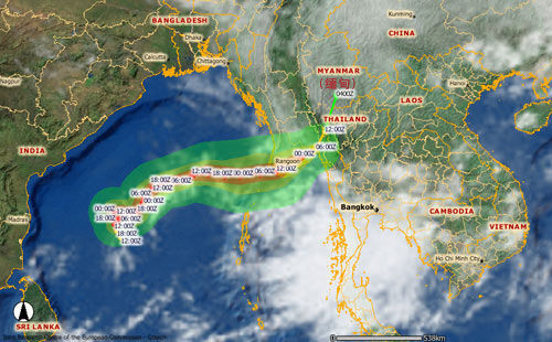
What is a tropical cyclone?

A tropical cyclone is a relatively small, intensely developed low pressure cell that usually occur over warm oceans. Its diameter can range between 200 and 2 000 km. It is characterized by a warm centre, very steep pressure gradients and strong cyclonic (clockwise in the southern hemisphere) winds near the Earth's surface. Tropical cyclones with a maximum wind speed of less than 60 km/h are called tropical depressions; when the maximum wind speed ranges between 60 and 110 km/h, they are tropical storms, and when the maximum wind speed exceeds 110 km/h, they are called tropical cyclones. (In the North Atlantic and eastern North Pacific regions it is called "hurricanes", in the western North Pacific "typhoons" .)
Formation
The process by which a disturbance in the pressure pattern forms and subsequently strengthens into a tropical cyclone depends on at least three conditions:
(1) Developing tropical cyclones gather heat and energy through contact with warm ocean waters. This usually happens between 5 and 20 North and South.
(2) The addition of moisture by evaporation of sea water from the sea surface powers them like giant heat engines, i.e. it draws its energy from the evaporation of sea water under the storm.
(3) A wind pattern near the ocean surface that spirals air inward, is also necessary.
The net result of these processes is a towering column of spiralling air with an intense low pressure in its centre. Bands of thunderstorms form, allowing the air to warm further and rise higher into the atmosphere.
Structure
The center, or eye, of a tropical cyclone is relatively calm and warm. The eye itself is clear, mainly because of gently subsiding air within it. The eye is extremely warm near the top of the storm circulation, reaching temperatures as much as 10C greater than that of the undisturbed environment at the same altitude. Near the sea surface the air has virtually the same temperature through the storm.
A spectacular wall of cloud (mainly cumulonimbus) rings the edge of the eye from sea level to heights of over 15 km. This ring of cloud, called the eyewall, maybe tens of kilometers thick, while a dense cirrus and altostratus overcast may extend outward several hundred kilometers from the eyewall. The most violent activity takes place in the eyewall. At the top of the eyewall, most of the air is propelled outward, increasing the air's upward motion.
The weather associated with tropical cyclones
Tropical cyclones are always accompanied by torrential rain. A single storm may yield up to 3 000 mm of rain. Heavy rains sometimes occur many days after landfall and are also very destructive. It may give rise to floods.
Because of the steep pressure gradient, strong winds occur. The wind speed rises rapidly from nearly zero in the eye to its maximum value at a radius between 10 and 100 km from the centre. The strongest winds occur near the leading edge ("in front") of the storm.
The destruction associated with tropical cyclones results not only from the force of the wind, but also from the storm surge and the waves it generates. The storm surge is experienced as a rapid rise of sea level near that portion of the eyewall associated with onshore winds, sometimes reaching a height of more than 6 meters and accompanied by very large wind-driven waves. Much of the death toll in tropical cyclones is due to the storm surge. The net result of the raised sea level, strong winds and torrential rains is to inflict severe damage on coastlines affected by the storm, especially those which are low-lying.
 0
0 


Comments