China names geographic entities on Diaoyu Islands
 0 Comment(s)
 Print
Print E-mail Xinhua, September 21, 2012


The State Oceanic Administration (SOA) and the Ministry of Civil Affairs on Friday jointly released a list of standardized names for the geographic entities on the Diaoyu Island and some of its affiliated islets.
 |
|
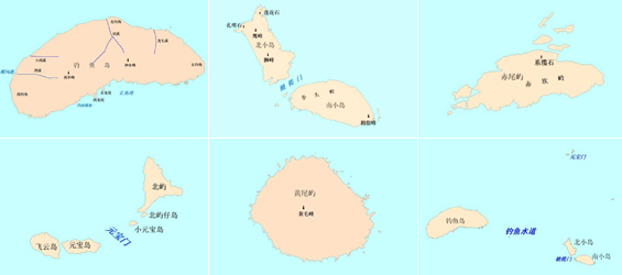
Location maps for the geographic entities on the Diaoyu Island and some of its affiliated islets released by the State Oceanic Administration (SOA) and the Ministry of Civil Affairs of China. [Photo: Xinhua] |
The list also relates to the surrounding waters of the islands.
The announcement details the Chinese-language names as well as the descriptions of the geographic locations of various mountains, creeks, capes and other geographic entities in the region.
The names, as normalized by the SOA and approved by the State Council, are accompanied by their pinyin codes, which refer to the phonetic system that romanizes Chinese characters.
The SOA also released a set of location maps for the geographic entities.
The fresh statement came after the SOA released on Saturday a string of geographic coordinates of the Diaoyu Island and some of its affiliated islets, in a new move to affirm China's sovereignty.
Saturday's announcement detailed the exact longitude and latitude of the Diaoyu Island and 70 of its affiliated islets, along with location maps, three-dimension effect graphs and sketch maps for the Diaoyu Islands.


Go to Forum >>0 Comment(s)