Top 10 most beautiful mountains in China
 0
0 


There are many mountain ranges in China. Mountainous land and very rough terrains make up two-thirds of Chinese territory. From the Tibetan Plateau and other less-elevated highlands rise rugged east-west trending mountains. China's spectacular mountain landscapes attract the professional climber and wide-eyed adventurer alike. The following are the "Top Ten Most Beautiful Mountains in China" ranked by China National Geography Magazine.
The criterion of China's Ten Most Beautiful Mountains are:
With unique well-worth appreciating value;
With the characteristics of that kind of geography shape and high scientific value;
Above 1000 meters in relative height, featured in the number and characteristics of vertical severity;
With high cultural values;
No excessive exploitation by humankind.
Location of China's Ten Most Beautiful Mountains

Namjagbarwa Peak (Tibet Autonomous Region): Paradise in the Clouds
Mountain Gongga or Minya Konka (Sichuan Province): Where the wind stops to rest
Qomolangma Peak (Tibet Autonomous Region): The soul's sentinel
Meili Snow Mountains (Yunnan Province): Guard of honor for the snow God
Huangshan Mountains (Anhui Province ): God’s miniature landscape
Three Sacred Mountains in Daocheng (Sichuan Province): Landmark of "Shangri-la"
Chogori Peak (Xinjiang Uygur Autonomous Region): Distant Mystic Land
Kangrinboqe Peak (Tibet Autonomous Region): Home of all the Gods
Mount Tai (Shandong Province): Totem of ancient China
Emei Mountain (Sichuan Province): The rise from a basin to the Heaven
1. Namjagbarwa Peak in Nyingchi, Tibet (南迦巴瓦峰).
Namjagbarwa Peak, located in Nyingchi Region of Tibet Autonomous Region, is reputed to be Paradise in the Clouds. The Qinghai-Tibet Plateau and the Himalayas have been hailed as humankind's last land of mystery. The most mysterious thing is that at each end of the Himalayas two peaks stand on the mysterious tectonic knots: at the eastern end stands Namjagbarwa (7,782 meters), the world’s 15th highest peak, and at the western end Nanga Parbat (8,125 meters), the world's ninth highest peak. They not only attach the magnificent length of the Himalayan chain to the southern edge of the Qinghai-Tibet Plateau, but also fix the Eurasian plate to the Indian plate.
In face of the Indian Ocean, it reflects an obvious vertical landform. In its valley is tropical rain forest and above the snow line, it is a snow world. Namjagbarwa has existed for over 700 million years, with a great abundance of mountain eco-systems, mountain vegetation forms and bio-communities compressed in one tight area. The first piece of land in the Himalayan region to emerge from the sea, it deserves its title of Number One among the Eastern Himalayan Mountains.
In Tibetan, Namjagbarwa means a "long lance piercing into the sky." The sky-scraping Namjagbarwa Peak, with its majestic appearance, precipitous shape and unpredictable climate, has been an ambitious aim of mountain-climbing organizations from various countries, and was only conquered recently by a Sino-Japanese climbing team in 1992.
2. Gongga Mountain in Sichuan (贡嘎山)

Mountain Gongga or Minya Konka is in Luding, Kangding and Jiulong County, Ganzi Tibetan Autonomous Prefecture, Sichuan Province. In Tibetan language, "Gong" means permanent snow cover, while "Ga" means white, so Gongga means white snow cover. It is located in the Miya Raogang area, a traditional Tibetan Buddhist administrative division. Local people also call it Miya Gongga.
The towering peak called Minya Konka rises to an awesome 7556 meters, making it the highest peak east of the Himalayas, and is the highest mountain in Sichuan Province. Minya Konka peak is high snowy peak with narrow ridges. While wildlife on the grasslands has been deeply affected by the changes in Tibet, remote mountain peaks and valleys often serve as refuges of isolation where wildlife remains abundant. In the high and steep Gongga Mountain, the snow does not melt perennially.
The climate of Minya Konka is moist, snowy and very changeful. Climbing is more difficult than QionmoLangma (Mt. Everest). Since 1932, only seven expeditions, with 22 people, have reached the summit of Minya Konka successfully.
A streak of blood-red light pierced the dark clouds, revealing over 50 steep snow-capped summits, shining, dazzling and thrusting into the clouds like golden swords. On the other side of the valley there were pinewoods, dark green in the sunshine, like green flower garlands above the mountain fields girdling the immeasurably high golden snow-capped summits. This ''Sunshine over the Golden Mountain'' is the most famous scenic view in the Gongga area.
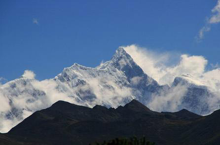
3. Qomolangma Peak/Everest in Tibet (珠穆朗玛峰)

Mount Qomolangma, also known as Mt. Everest, meaning Mother Goddess of the Universe, in Tingri County, Shigatse (Xigaze) Area of Tibet Autonomous Region, is the highest peak in the world. It straddles the border between China and Nepal. The main peak of the Himalayas, it is also the world's highest mountain. It has been called the most revered of all mountains and the world's third pole. The whole mountain looks like a huge pyramid, mighty and imposing. Its surrounding landforms are very steep and dangerous, making its ascent very difficult.
Qomolangma is 8,844.43 meters above sea level. Its northern slope is in Tingri County, Tibet, China and its southern slope lies within Nepal. It is a surrounded by towering mountains for a radius of 20 kilometers, more than 40 of them over 7,000 meters high. They include the famous Lhotse (the world's 4th highest peak) and Makalu (the world's 5th highest peak) to the southeast. There are other first-rate peaks beyond. Kangchenjunga (8,586 meters), the world's 3rd highest peak, is to the southwest, and to the west stand Gyachung Kang (7,986 meters), Cho Oyu (8,201 meters) and Gasherbrum (8,027 meters).
The North Col of Everest is located in Tinggri (Shegar). Massive glaciers and seracs feature a thrilling splendor. The peak has been a holy climbing attraction for world's mountaineers. In recent years, more and more mountaineers start from the Everest Base Camp trying to conquer the world's highest peak while tourists trek to the foot of the peak to enjoy its beauty.
Since the 18th and 19th centuries, explorers and mountaineers from other countries went to the Qomolangma Peak to explore its secrets. In the 1920s and 1930s, seven attempts were made by foreign mountaineering teams to climb Qimolangma via the north face, but all failed. A Chinese mountaineering team conquered the summit from the north face for the first time in 1960. Even today, it is still a cherished goal of countless mountaineers.
4. Meili Snow Mountains, Yunnan Province (梅里雪山)

The Meili Snow Mountain are located of the border between Deqing County in Diqing Tibetan Autonomous Prefecture, Yunnan and Zayu County in Tibet, lying deep in the Hengduan Mountain where the three waters of the Jinsha, the Langcang and the Nujiang riverw converge. It is a holy place of pilgrimage for Tibetan Buddhists, and the first of the eight great divine mountains in the Tibetan region.
At this place, 13 peaks average elevations over 6000 meters. Among of them, the Kawagebo (Tibetan call it) peak with 6740 meters high above the sea level is the highest one in Yunnan Province. Kawagebo in Tibetan is the God of Snow Mountain where is the sacred place for Buddhists. Nearby Kawagebo, 13 peaks line up, like a guard of honor for the God. During the period of the end of autumn and the beginning of the winter, a great number of devotees would come here to worship without thinking of how long the ways they have to go. It was admiring to see that they crawled to go up the high mountain gradually. In October 1989, the tenth Panchen Lama, Great Master of Tibetan Buddhism, held a grand religious meeting in front of Kagebo Peak, and now a stone tablet and a pagoda stand there welcoming tourists. In addition, at the foot of it, there are continuous glaciers and cirques known as the Modern Glaciers in the low latitude.
The complex geology of the Hengduan Mountain and the changeable climate in the low-latitude snow mountains mean that the Meili are fraught with fatal dangers. Violent glacier movements have aggravated fissures in the mountain body still further, giving rise to suspended glaciers, hidden ice crevices, ice avalanches and snow avalanches. Because of the precipitous massifs and perpetual snow, there are snow slides, dense fogs, heavy rain and fierce wind, and it is still a 'virgin peak" which none has conquered. However, it is most magnificent!
5. Huangshan Mountain, Anhui Province (黄山)
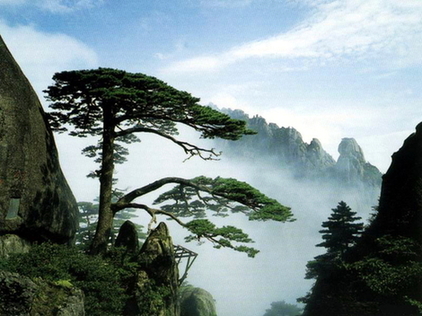
Mt.Huangshan in east China's Anhui province is one of Chinas ten best-known scenic spots. It was listed as one of the World Natural and Cultural Heritages in 1990. Huangshan is characterized by the four wonders, namely, odd-shaped pines, grotesque rock formation, seas of clouds and crystal- clear hot springs. Greeting Pine, on the left side of Jade Screen Tower, is a symbol of Huangshan scenery. Because of its mists and clouds, natural scenery in the area changes beyond prediction.
Mt.Huangshan is a marvel: within an area of 154 square kilometers there is a crowd of peaks, 72 of which have names indicating the shapes they resemble. Mount Huangshan extends 40 kilometers from south to north and 30 kilometers from east to west, covering an area of 1200 square kilometers, the highlights of which occupy 154 square kilometers. Lotus, Brightness Top and Celestial Capital are the three major ones, all rising above 1,800 meters above sea level. When it is cloudy the pinnacles loom in mists as if they were illusionary, while the sun is shining they unfold in all their majesty and splendor. MT.Huangshan change its color and appearance with the alternation of seasons. Here in Huangshan, pines and rocks are intimately involved with each other, almost every rock has a pine tree growing out of the crevice, and every tree has tortuous and gnarled roots and branches.The still sea of snow-white cloud can suddenly begin to roll and toss, rise or fall, gather or disperse while the peaks emerge and disappear in the clouds like isles in the ocean. So from ancient times it has been frequented by tourists seeking their mystery and admiring their frequented by tourists seeking their mystery and admiring their scenery.
As clouds often shut out the sun, hot weather never stays long, and this makes Mt.Huangshans an ideal summer resort. Mt.Huangshan lies in subtropical zones, so it's not quiet cold in winter, at least, not so cold as some people expected. The temperature ranges from 25 °F to 40 °F, but it's enough to result in a fantastic snow scenery and a silver world with pines and precipitous peaks covered with snow and decorated with icicles.
Today Mt. Huangshan has become a world-famous tourist attraction. With its convenient facilities: three cable lines, four three-star hotels on the top, all the paths paved with flat stones, it lures millions of visitors both from home and abroad. Seeing is believing. Welcome to Mount Huangshan.
6. Three Holy Mountains in Daocheng, Sichuan Province(稻城三神山)
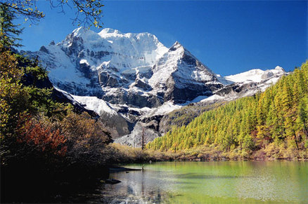
Three Sacred Mountains is located in Daocheng County, Ganzi Tibetan Autonomous Prefecture of Sichuan Province. From the meandering ranges, emerge the three sacred mountains of Daocheng: Xiannari, Yangmaiyong and Xianuoduoji. Since the ancient times, the three sacred mountains have been a sacred place for Tibetan Buddhism.
Xiannairi, the main peak of the three sacred mountains with an altitude of 6032m, is first among Daocheng's high peaks. According to legend, it is the incarnation of the Buddhist Goddess of Mercy Guanyin or Avalokitesvara. Its slopes are vast; its gradient gentle, the mountain looks like Great Buddha sitting in peace, graceful and poised.
Yangmaiyong, the south peak with an altitude of 5958m, means the Bodhisattva Manjusri. It is dignified and stately, gentle, quiet, noble and impeccable. It has a pyramid-as peak is the world's most beautiful snow mountain.
Xianuoduoji, the east peak with an altitude of 5958m, means the Buddha with warriors' hands, resembling a young man of strong character, tall and handsome. In Buddhism, it is the god of elimination brutality. He is brave and gallant and always in high spirits. He wears a brightly colored tiger skin around the hips, and a huge, fierce python circles his waist.
At their foot lie wide pasturelands, crisscrossed by brooks and streams flowing gently into lakes. There are woods and bushes too, and waterfalls formed by melting ice and snow creating captivating scenes. The famous sacred lake Wusehai, or ''Five-color Lake'', lies between Xianari and Yangmaiyong, 4,800 meters above sea level. The lake is oval shaped, and covers an area of 0.7 hectares. The snow mountains are reflected in the water and under refracted light; the lake surface produces five different fantastic colors. Many years later, the name of ''Shangri-La''----the imaginary utopia described in James Hilton's novel Lost Horizon----- was given to this place, a paradise sought by many people troubled by worldly life, and stirred up an abating tide of ''Returning to Nature.''
7. Chogori Peak in Xinjiang (乔戈里峰)

Chogori Peak, 8,611 meters in Yecheng County, Kashgar (Kashi) Region of Xinjiang Uygur Autonomous Region, is a transliteration of the Tajik language, meaning ''high, great and magnificent.'' Internationally, it is better known as K2, which is the only major mountain in the world that has surveyor's notation as its common name (K stands for Karakoram, 2 means it was the second peak listed).
Chogori Peak stands on the Chinese-Pakistan border. It lies in the middle of the Karakoram Range. Its southern slopes are in Pakistan, and its northern face is part of Yecheng County in Xinjiang Uygur Autonomous Region. There is an abundance of mountaineering resources.
It is more difficult to climb the Karakoram Range from the northern slope than from the southern slope. It is even more difficult to climb Chogori. First of all, the dangerous slope with an average gradient of 45 degree, as if shaped by knives and axes, are covered with steep cliffs and sliding chutes arising from avalanches. The vertical height difference is 4,700 meters. It is the biggest vertical height difference among the peaks 8,000 meters above sea level in the world. The steep slope makes it extremely difficult to find safe places for setting up high-altitude camps. Because of its special landform and geomorphology, ropes have to be fixed along the whole route from the advance camp to the summit. The gradient is between 80 degree and 85 degree in some places, and there is almost nowhere for team members to rest.
Of all the 8,000 meters plus peaks, Chogori has the third highest death rate. The dangerous landform and changeable weather have caused a death rate as 30% in attempts on the summit. Since 1954, only 164 people have scaled the summit, and 49 others have been killed. This great peak is for expert climbers only. This is Chogori! In the eyes of the top-class mountaineers, it is the most beautiful peak; it is its matchless danger that seduces them. This is what the great Chogori means to the world's top-class mountaineers.
8. Kangrinboqe Peak in Nagri, Tibet (冈仁波齐峰)

The Gandise Mountain lies from east to west in the south of Tibet. Among its steep cliffs and glaciers is its main peak, Kangrinboqe, located in Pulan County, Ali Prefecture in Tibet. It is a world-acknowledged holy mountain and regarded as the center of the world by Hinduism, Tibetan Buddhism, Bon (the primitive religion of Tibet) and ancient Jainism. About 6,638 meters above sea level, the mountain is powerful and imposing, holding a sacred position in many religions. The whole mountain seems to be made of crystal, looking like a jade-inlaid ice sculpture of extremely skillful artisanship.
It is the summit of the Gangdese Mountains, and enjoys worldwide fame is far behind Qomolangma (Mount Everest). It is also the source of four of Asia's major rivers. From the snow-capped summit rise the Shiquan (which become the River Indus), the Maquan (which becomes the Yarlung Tsangpo River and then the Brahmaputra), the Xiagnquan (which becomes the Sutlej River) and the Kongque (which becomes the Ganges). Kangrinboqe's crystal-clear and white snow-capped summit and Mount Namnani, which Tibetans call the ''Mountain of the Goddess,'' face each other from afar. Between the two lie the beautiful holy and pure Mapangyongco Lake and the changeable Devil Lake----La'angco.
The Tibetans call the peak "Kangri," which means "treasure of the snowy mountains." In Buddhism and Hinduism, this peak occupies a position as important as the Mandala, or the center of the universe. For hundreds of years, pilgrims have come in a continuous stream to the mountain, which has taken deep root in Tibetan religion, history, and culture. Mystical and fascinating, it is a mountain of spirit, culture, and belief, a combination of man and divinity, and man and nature. Many Tibetan religious followers enshrine and worship the picture of Kangrinboqe together with the figure of Buddha in their homes. Kangrinboqe is a symbol, not only of natural beauty, but also of a belief. Kangrinboqe has always been an enchanting place for pilgrims and explorers, but up until today, not a soul has been able to scale the holy mountain or dared to trespass into the center of this world.
9. Mount Tai, Shandong Province (泰山)
Mt.Tai is located in the middle of Shandong Province, with a total area of 426 sq km. As the highest peak in Shandong with an elevation of 1,545 meters, Mt. Tai is called "Chief of the Five Sacred Mountains" and "First Mountain Under Heaven."
With its abundant cultural treasures, Mt.Tai is honored as a sacred mountain and the symbol of Chinese national spirit. From ancient times to the Qing Dynasty, emperors came to this reverend peak to hold grand ceremonies to worship the Gods of Heaven and earth. On the mountain there are 22 ancient construction complex, over 100 other buildings, more than 1,800 above carved stones, nearly 20,000 ancient trees and numerous poems and masterpieces written by scholars throughout different dynasties, all of which make Mt. Tai the epitome of oriental culture.
Formed about 28 hundred million years ago, Mt.Tai is famous for its imposing natural landscape. Besides its majesty, the Sunrise, Sunset Glow, Golden Belt of the Yellow River, the Sea of the Clouds are its four wonders. In 1987, Mt.Tai was listed as both a world natural and cultural heritage by UNESCO. It was the first place named as double heritage to the world. Experts of the World Heritage Committee of UNESCO said, "Mt.Tai uniquely unites nature and culture together, and this means China has contributed a special heritage to the world."
10. Emei Mountain, Sichuan Province (峨眉山)

E'mei Mountain lies in E'meishan City of southwest Sichuan Basin. E'mei Mountain Scenic Area is famous for the characters of grandness, elegance, wonder and fantasticality with the reputation of "Beauty Under Heaven". The mountain stretches 23 km from south to north with an area about 115 sq m. Hillsides are always gentle in the west and steep in the east. The eastern slopes are converse with some fault cliffs, and they are rugged and steep. Its main peak, Wanfo Top, is 3,099 m above sea level, and it is 2,600 m higher comparing with E'mei Plain on its eastern piedmont.
E'mei Mountain can be considered as a huge natural arboretum and the kingdom of wild animals.There are many kinds of plants and animals in E'mei Mountain, and more than 3,000 kinds of superior plants and over 2,000 kinds of animals are existed up to now. Most of them are rare species. Moreover, giant panda, Tibetan macaque and other 29 species are major animals under state protection. As to plants, Gong Tung and Gingko is the living fossil of tertiary. 107 categories plants are unique of E'mei Mountain, and more than 30 varieties are major plants under state protection.
The four great spectacles of Mt E'mei: Sunrise is amazing on Golden Summit. Cloud sea will rise slowly among the mountain when the sky is clearly blue. Buddhist halos with the color of red, orange, yellow, green, black blue, blue and purple extends a radius of around one to two meters at the foot of Sheshen Rock in the afternoon. Saint Lamp is the famous scenery in Mt Emei.


Go to Forum >>0 Comments