|
NATIONAL FLAG, NATIONAL EMBLEM, NATIONAL CAPITAL, NATIONAL ANTHEM|ADMINISTRATIVE DIVISION GEOGRAPHICAL FEATURES|NATURAL RESOURCES|CLIMATE|POPULATION, ETHNIC GROUPS |
|
Rivers |
|
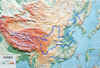
China abounds in rivers, totaling 220,000 km in length. There are more than 1,500 rivers, each having a drainage area of over 1,000 square km. Due to topographical features, most rivers flow east or south into the ocean, thus forming vast outflow river valleys that constitute nearly two-thirds of the national total drainage area. Most of them belong to the Pacific Valley and a small number fall into the Indian Ocean Valley. Only the Erix River that runs west out of China belongs to the Arctic Ocean Valley. The total volume of runoff stands at 2,711.5 billion cubic meters, almost equivalent to the total in Europe. Because most of the main rivers originate from the Qinghai-Tibet Plateau with big falls, China has abundant waterpower resources, with total reserves of 680 million kw, ranking first in the world. |
|
||
|
Yangtze River |
|
Yangtze River: The largest in China, it rises in Geladandong, the main peak of the Tanggula Mountain Range. It flows 6,300 km eastward traversing 10 provinces, autonomous regions and municipalities before emptying into the East China Sea. It has numerous tributaries, with a combined drainage area of 1.8085 million square km, accounting for 18.9 percent of China’s total land area. Its annual average runoff stands at 951.3 billion cubic meters. |
|
Yellow River |
|
Yellow River: The second largest in China, it originates from the northern foot of the Bayan Har Mountain in Qinghai Province. It flows 5,464 km easterly across nine provinces and autonomous regions, with a drainage area of more than 752,400 square km. Its annual average runoff is 66.1 billion cubic meters. It has more than 40 main tributaries. The middle section of the river traverses the Loess Plateau with loose soils, making it a river with highest silt content in the world. |
|
||
|
Beijing-Hangzhou Grand Canal |
|
Beijing-Hangzhou Grand Canal: Starting from Beijing in the north, it extends 1,801 km to Hangzhou, Zhejiang Province in the south. First dug in the fifth century BC, the canal served as an important channel for the transport of grain in ancient China. Its southern section is still navigable. |