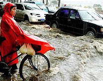
Floods are threatening eastern and central China while the west and north suffer drought.
Last year, floods and droughts led to economic losses totaling 200 billion yuan (US$24 billion). Floods hit 30 provinces, autonomous regions and municipalities, damaging 20 million hectares of farmland, destroying 2.5 million houses and affecting 220 million people.
Droughts hit the northeast last spring and the south last summer, affecting 25 million hectares of farmland and 24.4 million people.
This year, northwest China's Shaanxi Province has been hit by an unusual drought. Sunday marked the ninth consecutive day with temperatures higher than 35 degrees Celsius in the provincial capital of Xi'an.
Meanwhile, water levels on the middle and lower reaches of the Yangtze and Huaihe rivers have risen steadily since the rainy season began earlier this month, creating a severe test for flood control facilities.
Most of the 12 hydraulic observation centers along the Yangtze River, China's largest, have reported higher water levels since June 16.
Embankments along the river's main trunk and its tributaries remain weak. Flood-relief capability in many areas is poor, and undetected problems are certain to have arisen at some reservoirs since the Three Gorges began to store water.
Vice Premier Hui Liangyu said earlier this month that the Haihe River is also likely to flood again this year since the river course and estuary have severe silt problems. Hui was conducting a five-day inspection of dykes, reservoirs and major flood control projects within the Haihe River valley.
Covering an area of 318,000 square kilometers, the valley includes parts of Beijing and Tianjin municipalities, Hebei, Shandong and Shanxi provinces and the Inner Mongolia Autonomous Region.
"The flood and drought prevention work within the valley is very important due to its strategic location as well as the dense population and numerous cities it contains," Hui said.
Shanghai is using satellite communications and global positioning systems along with remote sensing to keep track of the city's 85 floodgates and meteorological conditions. Data collected through the system are transferred to the city's water, weather and other departments every 15 minutes.
The flood season usually hits Shanghai from June to September, bringing with it high winds, heavy rainfall and high tides.
On Monday, the State Environmental Protection Administration warned governments at all levels to be prepared to prevent possible pollution brought by floods.
(Xinhua News Agency June 29, 2004)