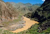
Warm and dry weather in the Qinghai-Tibet Plateau in recent years has lowered the inflow of water to the Yellow River.
The water inflow in the upper reaches of the Yellow River, the country's second longest, has continuously shrunk since the 1990s due to dry and warm weather caused by global warming, meteorologists with Qinghai Meteorological Bureau said.
The bureau's statistics show average runoff reached 375 cubic metres per second in 2002, only 58 percent of the average volume in past decades, reported China Daily on Tuesday.
Rainfall, which provides the main inflow of water into the river's upper reaches, has seen sharp reductions in recent years.
At the same time, evaporation in rivers across the country is expected to increase by 15 percent, said Ding Yihui, an expert from China Meteorological Administration.
Ding said global warming could reduce crop outputs across the country by 5 to 10 percent in 2030, Xinhua said.
Overuse of energy and excessive discharge of greenhouse gases such as carbon dioxide are both main causes of global warming.
Water shortages in the Yellow River have already cut down on crop outputs along the river basin's grain production provinces such as Henan and Shandong.
Since 1998, Qinghai has started campaigns to increase rainfall in upstream areas of the Yellow River.
Besides declines in the water level, the Yellow River is faced with many other challenges including shrinking watercourses in the lower reaches and higher levels of silt, water experts said at a meeting on Yellow River control and management over the weekend in Zhengzhou, capital of Central China's Henan Province.
Sediment on the river bed in Shandong and Henan provinces has filled up many watercourses, threatening people's safety, said Chen Lei, vice-minister of water resources.
More than 1.8 million people live in the flood plains in Henan and Shandong provinces along the lower reaches.
The river's principal problem has always been the silt deposits caused by exceptionally high levels of sediment.
The river now carries some 1.6 billion tons of silt annually with a quarter of this deposited on the river bed downstream, water experts said.
The river bed in the lower reaches was up to 10 meters higher than the surrounding fields in the Henan and Shandong sections, leading to the Yellow River being described as a "hanging river."
Worst of all, a substantial amount of sediment left behind has contributed to the silting of the river course. This has significantly raised the river bed and built up another "hanging river" between its trunk stream and the flood plains bordering it.
Once a notorious troublemaker, the Yellow River used to regularly burst it banks and change its course every century or so.
The 5,464-kilometre-long Yellow River originates on the Qinghai-Tibet Plateau, winds its way through eight provinces and autonomous regions, and empties into the Bohai Sea.
(China Daily November 16, 2004))