In a mirage, the desert sands can mirror the image of a lake.
But as Liu Ning, chief engineer of the Ministry of Water Resources points to a vast expanse of water stretching to the horizon in the hinterland of the Tarim Basin in Xinjiang Uygur Autonomous Region, he assures visitors that this revived lake is indeed very real.
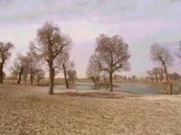
A record 200-square-kilometre body of water has accumulated in Taitema Lake at the end of the Tarim River, China's longest inland waterway.
The 1,321-kilometer Tarim River runs west to east along the northern edge of the Taklimakan Desert, China's largest, and flows into Taitema Lake.
The river is the most important source of water in semi-arid Xinjiang, with more than 8 million people living in oases clustered along its banks and in an alluvial plain downstream.
Yet, due to the increasing population, excessive water use for irrigation, and random land reclamation upstream, the lake has been drying up for three decades.
To prevent further deterioration of the ecosystem, the central government launched a five-year emergency water diversion program in 2000 with 10.7 billion yuan (US$1.3 billion) earmarked for the reclamation of the river and Taitema Lake.
In recent years, some 1.3 billion cubic meters of water has been released from Bosten Lake north of the Tarim River to flow downstream into the dry riverbed.
The latest water diversion started in late March this year and water is now flowing into the river at a maximum speed of 50 cubic meters per second. Some 300 million cubic meters are expected to be diverted, Liu says.
Green corridor
In semi-arid Xinjiang, where there is water there is hope, particularly for the Tarim, a river surrounded by deserts.
To date, a green corridor along the river between the 410,000-square-kilometre Taklimakan Desert on the east and Kuluke Desert on the west, is being revived thanks to the diverted water.
Standing beside the lake, Zhu Xiangmin, director of the Tarim River Authority (TRA), marvels that its current area is the largest since 1972 when it first dried up.
A national highway built along the dried riverbed used to be buried under a thick blanket of sand, but now the clean water flows over parts of the No 218 National Highway around the rim of the lake.
Temporary bridges have had to be built across the inundated roadbed to let water flow into the lake on the other side.
Following the river's revival, vegetational response, such as the growth of shrubs and poplars, can be seen along the banks of the Tarim River, Zhu wrote in his latest research report.
Along the highway adjacent to the river, many of the formerly parched desert shrubs are sprouting again. New buds on Chinese tamarisk and poplar are prevalent in spring.
In some downstream sections the recovery of natural vegetation has extended to 18,000 hectares, according to the latest statistics by TRA using remote sensing technology.
A stretch of 800 square kilometers of poplar (called huyang in Chinese), which locals believe has a legendary vitality for 1,000 years, has been rejuvenated along the river with the rising groundwater level, which so far has climbed by seven meters.
Three years ago, areas where groundwater could be detected at a depth of four meters accounted for only 5 square kilometers. Today, that area has increased to 20 square kilometers.
Endangered ecosystem
The landscape downstream and in surrounding areas was quite different years ago following the river's dry-up.
A 400-kilometer section of the lower reaches and Taitema Lake dried up beginning in 1972, and vast stretches of Chinese tamarisk and poplar forests shriveled and died.
Worst of all, some riverside villages had to be abandoned when drinking water was no longer available.
Yengisu, a village with more than 30 households of Uygur herdsmen next to the old Tarim River in Ruoqiang County, fell into ruins.
"I had to move out of my hometown to make a living for my family in another place after the river died up," says Jialali, a 112-year-old Uygur from his new house beside the 218 National Highway.
Catastrophic droughts and sandstorms also became a menace to the local economy.
Diversion program
The water diversion program, slated to be completed by 2005, is aimed at protecting the green corridor and long belt of oases.
Between 2000 and 2003, 1.3 billion cubic meters of water was diverted from Bosten Lake in central Xinjiang, together with 700 million cubic meters of water from a nearby reservoir.
By the end of last year, about 90 percent of the program's 113 planned water conservancy projects were under construction or in full swing.
By 2005, Liu says, hundreds of water control works are scheduled to be built to regulate and optimize the region's water supply and the management of water resources on the upper, middle and lower riches of the Tarim River.
Best is yet to come
Reviewing the changes to the river and the water transfer, Liu says: "Feeding water to the thirsty river downstream can only be used as a makeshift for its rehabilitation. I hope the green corridor or long belt of oases along the river can be revised, and from now on water will be supplied. If that happens, this will once again become a promising land for the people in Xinjiang."
As water runs in the 360-km section of the lower reaches of the river, the water table underneath the corridor is going up three to five meters, and poplars covering an area of 600 square kilometers along the river are benefiting from rising underground water.
"The filled water has not only brought withered plants back to life, but also helped carry seeds of more plants to the banks of the lower reaches, promising a more vibrant future," said Xia Xuncheng, a senior researcher with the Xinjiang Ecological and Geological Studies Institute of the Chinese Academy of Sciences.
Although rehabilitation of ecosystem has been good so far in the lower reaches of the Tarim River, Lu Yaoru of the Chinese Academy of Engineering said he hopes a fundamental solution to the river's further rehabilitation can be found. "For that purpose, there is still a long way to go," Lu stressed.
During a recent appraisal of the water transfer program, Lu and other scientists attributed the success to the consecutive high-flow years of local rivers and the Bosten Lake close to the Tarim.
However, the series of water diversions that started in 2000 cannot solve all the problems if other supporting measures are not adopted, experts and scientists say.
This water diversion program is the most expensive environment restoration project ever to take place in Xinjiang, "but it's only paved a way for us to harness the river and improve its ecosystem," Liu says.
Fortunately, various grassroots administrative regions along the river have recognized the importance of the water and pledged all-out efforts, such as mass construction of water conservation projects to reduce regional evaporation, limit seepage loss, promoting recycling, water efficient irrigation and spreading water-saving tips among locals, to secure the river's revival.
"Only by having humans living in harmony with nature can we ensure a bright future for the Tarim River," Liu says.
(China Daily April 14, 2004)