|
NATIONAL FLAG, NATIONAL EMBLEM, NATIONAL CAPITAL, NATIONAL ANTHEM|ADMINISTRATIVE DIVISION GEOGRAPHICAL FEATURES|NATURAL RESOURCES|CLIMATE|POPULATION, ETHNIC GROUPS |
|
|
|
Rivers |
 |
|
Summary |
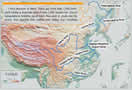
China abounds in rivers. There are more than 1,500 rivers, each having a drainage area of over 1,000 square km. Due to topographical features, most rivers flow east or south into the ocean, thus forming vast outflow river valleys that constitute nearly two-thirds of the national total area. Most of them belong to the Pacific Valley and a small number fall into the Indian Ocean Valley. Only the Erix River that flows westerly out of China belongs to the Arctic Ocean Valley. The total volume of runoff stands at 2,711.5 billion cubic meters, almost equivalent to the total in Europe. Because most of the main rivers originate from the Qinghai-Tibet Plateau with big falls, China has abundant waterpower resources, with total reserves of 680 million kw, ranking first in the world. Famous rivers in China include the Yangtze River, the Yellow River, the Heilongjiang River, the Yarlung Zangbo River and the Huaihe River. The Tarim River in Xinjiang is the largest inland river in China. Running across deserts, it has been known as the "river of life".
|
|
Yangtze River: |
Yangtze River: The largest in China and third longest in the world, the Yangtze River rises in Geladandong, the main peak of the Tanggula Mountain Range. It flows 6,300 km eastward traversing 10 provinces, autonomous regions and municipalities before emptying into the East China Sea. It has numerous tributaries, with a combined drainage area of nearly 1.81 million square km, accounting for 18.9 percent of China's total area. Its annual average runoff stands at 951.3 billion cubic meters. It is a major artery of inland water transportation in China.
|
|
Yellow River: |
Yellow River: The second largest in China, the Yellow River originates from the northern foot of the Bayan Har Mountain in Qinghai Province. It flows 5,464 km easterly across nine provinces and autonomous regions, with a drainage area of more than 750,000 square km. Its annual average runoff is 66.1 billion cubic meters. It has more than 40 tributaries, of which Fenhe and Weihe rivers are the main ones. The middle section of the river traverses the Loess Plateau with loose soils, making it a river with highest silt content in the world. Due to piling sediments, the riverbed of many downstream sections of the Yellow River is higher than the surrounding land.
|
|
Heilongjiang River: |
Heilongjiang River: Situated in the northernmost part of China, it has a drainage area of more than 1.62 million square km. |
|
Songhuajiang River: |
Songhuajiang River: It flows 2,308 km, with a drainage area of 557,180 square km and an annual runoff of 76.2 billion cubic meters. |
|
Liaohe River: |
Liaohe River: It flows 1,390 km, with a drainage area of 228,960 square km and an annual runoff of 14.8 billion cubic meters. |
|
Pearl River: |
Pearl River: The largest in south China, it flows 2,214 km, with a drainage area of 453,690 square km and an annual runoff of 333.8 billion cubic meters. In terms of the runoff volume, the Pearl River is considered the second largest in China, next to the Yangtze River.
|
|
Huaihe River: |
Huaihe River: It flows 1,000 km, with a drainage area of 269,238 square km and an annual runoff of 62.2 billion cubic meters.
|
|
Beijing-Hangzhou Grand Canal: |
Beijing-Hangzhou Grand Canal: Starting from Beijing in the north, it extends 1,801 km to Hangzhou, Zhejiang Province in the south. First dug in the fifth century BC, the canal served as an important channel for the transport of grain in ancient China. The canal is the earliest and longest artificial waterway in the world, and its southern section is still navigable.
|