|
NATIONAL FLAG, NATIONAL EMBLEM, NATIONAL CAPITAL, NATIONAL ANTHEM|ADMINISTRATIVE DIVISION GEOGRAPHICAL FEATURES|NATURAL RESOURCES|CLIMATE|POPULATION, ETHNIC GROUPS |
|
|
|
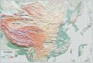
Basins |
 |
|
Tarim Basin: |
Tarim Basin: Situated in the southern part of the Xinjiang Uygur Autonomous Region, it is China's largest basin embraced by the Tianshan and Kunlun mountain ranges. With its base averaging 800-1,300 meters above sea level, the basin is widely covered with deserts. Taklimakan in the center of the basin is the largest desert and a region with one of the largest oil and gas reserves in China. |
|
Junggar Basin: |
Junggar Basin: Situated between the Tianshan Mountains and Altay Mountain in north Xinjiang, it is the second largest basin in China, with its base averaging 500-1,000 meters above sea level. With its central part covered with grasslands and deserts, the basin abounds in coal and oil reserves. |
|
Qaidam Basin: |
Qaidam Basin: Situated in the northeast of the Qinghai-Tibet Plateau, it is surrounded by the Kunlun and Qilian mountain ranges. With its base averaging 2,700-3,000 meters above sea level, it is the highest basin in China. It has rich reserves of mineral resources, including salt, coal, oil and nonferrous metals. |
|
Sichuan Basin: |
Sichuan Basin: Situated in east Sichuan Province, it is surrounded by Wushan and Daba mountains, with its base averaging 400-800 meters above sea level. Chengdu Plain is in the northwest of the basin.
|
|
Turpan Basin: |
Turpan Basin: Situated at the eastern terminus of the Tianshan Mountains in central Xinjiang, it is China's lowest basin, with its base located 154 meters below sea level.
|