|
NATIONAL FLAG, NATIONAL EMBLEM, NATIONAL CAPITAL, NATIONAL ANTHEM|ADMINISTRATIVE DIVISION GEOGRAPHICAL FEATURES|NATURAL RESOURCES|CLIMATE|POPULATION, ETHNIC GROUPS |
|
|
|
Main Mountain Ranges |
 |
|
Summary |
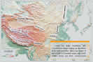
China has many mountains, with mountainous areas making up two-thirds of its total land area. China has seven of the world's 12 mountain peaks over 8,000 meters above sea level. Crisscrossing each other in different trends, high mountain ridges have been shaped into many mountain systems, forming the framework of China's topography. Well-known mountain ranges in China are the Himalayas, the Kunlun Mountains, the Tianshan Mountains, the Qinling Mountains, the Greater Hinggan Mountains, the Taihang Mountains, the Qilian Mountains and the Hengduan Mountains
|
|
Himalayan Mountains: |
Himalayan Mountains: Extends more than 2,400 km in an arc-shape along the Chinese-Indian and Chinese-Nepalese borders. Averaging 6,000 meters above sea level, it is the world's highest and largest mountain range. Its main peak, Qomolongma, is 8,848.13 meters above sea level, the highest in the world.
|
|
Kunlun Mountains: |
Kunlun Mountains: Extends 2,500 km from the Pamirs Plateau in the west to the northwest of Sichuan Province, with an average elevation of 5,000 to 7,000 meters. Its main peak, Muztag, is 7,723 meters above sea level. |
|
Tianshan Mountains: |
Tianshan Mountains: Runs through the middle of the Xinjiang Uygur Autonomous Region, with an average elevation of 3,000 to 5,000 meters
|
|
Qinling Mountains: |
Qinling Mountains: Stretches from east Gansu Province in the west to west Henan Province in the east, with an average elevation of 2,000 to 3,000 meters. Its main peak, Taibaishan, is 3,767 meters above sea level. The mountain range is an important geographic line of demarcation between north and south China. |
|
Greater Hinggan Mountains: |
Greater Hinggan Mountains: Extends 1,000 km from Mohe of Heilongjiang Province in the north to the upper reaches of Laoha River in the south, with an average elevation of 1,500 meters. Its main peak, Huanggangliang, is 2,029 meters above sea level.
|
|
Taihang Mountains: |
Taihang Mountains: Extends over 400 km along the eastern fringe of the Loess Plateau from north to south, with an average elevation of 1,500 to 2,000 meters. Its main peak, Xiaowutaishan, is 2,882 meters above sea level. |
|
Qilian Mountains: |
| Qilian Mountains: Stretches along the northeastern
fringe of the Qinghai-Tibet Plateau, with an average elevation of 4,000
meters. Its main peak, Qilianshan, is 5,547 meters above sea level.
|
|
Hengduan Mountains: |
Hengduan Mountains: Situated at the juncture of Tibet, Sichuan and Yunnan in the southeast of the Qinghai-Tibet Plateau, with an average elevation of 2,000 to 6,000 meters. Its main peak, Yulongshan, is 5,596 meters above sea level. |