|
NATIONAL FLAG, NATIONAL EMBLEM, NATIONAL CAPITAL, NATIONAL ANTHEM|ADMINISTRATIVE DIVISION GEOGRAPHICAL FEATURES|NATURAL RESOURCES|CLIMATE|POPULATION, ETHNIC GROUPS |
|
|
|
Plains |
 |
|
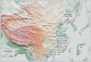
Northeast China Plain: |
Northeast China Plain: Situated in northeast China, it lies between the Greater and Lesser Hinggan and Changbai mountains. Covering 350,000 square km, it is China's largest plain, with an elevation of lower than 200 meters. The Songhuajiang, Nenjiang and Liaohe rivers run through its vast and fertile land. |
|
North China Plain: |
North China Plain: Bordering on the Taihang Mountains in the west, the coast in the east, Yanshan Mountain in the north and Huaihe River in the south, it covers 310,000 square km, with an elevation of lower than 50 meters. Formed of alluvial deposits from the Yellow, Huaihe and Haihe rivers, it is also known as the Yellow River-Huaihe-Haihe Plain. It has a smooth terrain and vast fertile land. |
|
The Plain in the middle and lower reaches of the Yangtze River: |
The Plain in the middle and lower reaches of the Yangtze River: Stretching eastward from Wushan Mountain to the coast, it was formed of alluvial deposits from the Yangtze River and its tributaries. With part of it lower than 5 meters in elevation, it is generally lower than the North China Plain. Crisscrossed by many rivers and dotted with lakes, the plain is known as "a land flowing with milk and honey". |
|
Pearl River Delta Plain: |
Pearl River Delta Plain: Close to Guangzhou, Guangdong Province, it covers 11,000 square km, with an average elevation of about 50 meters. It has crisscrossing rivers and is dotted with isolated hills.
|
|
Hetao Plain: |
Hetao Plain: Lying along the banks of the Yellow River in the Inner Mongolia and Ningxia Hui autonomous regions, it has an elevation of less than 1,000 meters. It is known as "a lush southern-type land north of the Great Wall".
|