Japanese philosopher Daisaku Ikeda once asked Dr. Arnold Toynbee, in the course of their discussions in the early 1970s, in which age and place in history he would choose to be born. The late British historian promptly replied Xinjiang during the early C.E. era, the time when Mahayana Buddhism came to East Asia from India by way of Xinjiang, which was a conglomeration of Indian, Greek, Iranian and Chinese cultures.
Buddhism entered China through Xinjiang by way of the Old Silk Road that connected then capital Chang'an (today's Xi'an) with Central Asia and Europe. Followers of other religions and philosophies, such as Zoroastrianism, Manichaeism, the Nestorian Church, Taoism from inland China, and Islam, also came to Xinjiang from kingdoms and regions along the Old Silk Road.
This road leading from China to Europe was first trodden for commercial reasons, and by the Western Han Dynasty (206 BC – AD 24) it had been made an official trading channel. Merchants traveling along it were guarded by troops dispatched by the central government. As China's main commodity export was silk, German geologist Ferdinand von Richthofen named it the Silk Road. His student Sven Hedin, famous Xinjiang explorer and archaeologist, so described it: "The Silk Road measures 4,200 miles as the crow flies, and including its bends has a total length of 6,000 miles, equivalent to a quarter of the equator.... It is no exaggeration to say that this line of communications was the longest road ever to traverse the entire old world. From a cultural and historic point of view, it was the most significant link between nationalities and continents on earth."
At the start of the millennium, when camels, horses and carts were the main means of transportation, this road to and from Chang'an took more than three years to travel, but fortunes could be made in that time. In the Tang Dynasty (618-907), for example, the price of silk in the East Roman Empire was a hundred times that in China. There was, therefore, commercial motivation to travel this profitable thoroughfare that brought about the cultural dissemination and ethnic interchange that so distinguishes Xinjiang from the interior provinces.
This commerce certainly raised China's early inland inhabitants' standard of living. They were among the earliest to master the techniques of silkworm raising and silk weaving, but the cotton textile technology that opened up a new source of cheap clothing fabric on the Central Plains came from Xinjiang. Prior to the Han Dynasty, the main vegetables available in the interior were the Chinese onion, scallion and Chinese chives. Eggplant, spinach, lettuce, kidney beans, sword beans, carrots, broad beans and garlic, and fruits such as grapes, pomegranates and walnuts, arrived there by way of Xinjiang. It was also along the Old Silk Road that Chinese tea and porcelain, silkworm-raising techniques and the Chinese inventions of gunpowder and papermaking came to the West.
The Old Silk Road had three routes – northern, central and southern -- within the territory of Xinjiang, along which were 36 city-states with advanced civilizations. Some still flourish, while others, long since been abandoned, lie buried under the desert sands. Their discovery and excavation produced the most important archaeological findings of the 20th century.
Loulan: Ghost City
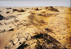
Loulan was a city along the central Old Silk Road where the Han Dynasty (206 BC – AD 220) central government set up its administrative organs. By the fourth century it was the most prosperous city in Xinjiang with a population of 14,000, where merchants of all nationalities converged. After peaking in the fourth century Loulan went into rapid decline. There are no records of Loulan extant beyond the fifth century. Tang Dynasty Monk Xuanzang wrote in his travel notes on his scripture seeking pilgrimage to India, "The city and houses still stand, but there are no people." Archaeologists conclude that a change in river course and deterioration of the natural environment led to the city's abandonment.
Since Sven Hedin discovered the Loulan City ruins in 1900, it has drawn a steady stream of fascinated visitors from China and beyond. Archaeologists have unearthed the ruins of government offices, residences, and Buddhist pagodas, as well as exquisite silk fabrics and glassware. Their most significant finding was a female mummy, the "Loulan beauty," whose good looks 1,000 years later, are undiminished.
The Loulan ruins are in western Lop Nur in the midst of desert, Yardang landform and hard salt shell where sandstorms are frequent and the weather is changeable. Here the temperature often hits 40 degrees Centigrade at noon and plunges to zero after sunset. The road to Loulan is not easily traveled. It takes several days by cross-country vehicle from Xinjiang's Ruoqiang, Korla and Turpan, or from Gansu's Dunhuang. Vehicles can travel no faster than two to three kilometers per hour in the Loulan area, as every two minutes an average three sharp turns must be made.
Other ancient ruins not to be missed in Xinjiang are those of the Niya, Kaladun, Milan, Nirang, Khan and Liushi cities.
Kuqa: Thousand-Buddha Grottoes, Grand Mosque, and Diversiform-leaved Poplar Forest
Kuqa is in southern Xinjiang at the southern foot of the Tianshan Mountains. Formerly an important town on the central Old Silk Road, it is now under the jurisdiction of Aksu Prefecture. It was here that, influenced by multiple cultures, the Qiuci civilization as represented by famous Qiuci City was formed. In common with many of Xinjiang's ancient cities, Qiuci City was discovered after having disappeared for more than 10 centuries.
Aksu Prefecture is easily accessible by highway, railway and air. It has many cultural sights, most notably its Buddhist grottoes, such as the Kizil, Kumutura, Mazabeg and Simsem grottoes. The Kizil Grottoes, dug in the late third century over a period of more than 500 years, are China's earliest, largest and westernmost Buddhist grottoes. They comprise 236 numbered caves and 10,000 square meters of murals, most of which relate to Buddhism.
It was the Grand Kuqa Mosque, first built in the 16th century and reconstructed in 1931 after being damaged by fire, that first signified dominance of Islam over Buddhism in Xinjiang. It is the region's second largest mosque after the Id Kah Mosque in Kashi and has capacity for 3,000 worshipers. Within its compound is Xinjiang's sole religious court. Kuqa is also site of the sacred Molanaershiding Tomb to which Xinjiang's Muslims make regular pilgrimages.
Along the banks of the Tarim River on the edge of the Taklimakan Desert, largest in China and second largest in the world, grows the world's largest diversiform-leaved popular forest. This tree species is celebrated for its capacity to "live for 1,000 years, stand for 1,000 years after death, and resist decay 1,000 years after falling down." In autumn, its leaves turn a spectacular yellow, as featured in Zhang Yimou's Hero.
Other sights of natural beauty in Aksu Prefecture include Mount Tomur -- site of China's largest modern glacier, the Taklimakan Desert, the Mystic Grand Canyon of the Tianshan Mountains, and the South Heavenly Pool. Aksu's rich water resources make it Xinjiang's main producer of apples, pears, thin-shelled walnuts, grapes, white apricots, peaches and dates.
Hotan: Home of Jade
Hotan, in the southern Tarim Basin, was originally site of the Yutian Kingdom and its 80,000 population that dominated the southern route of the Old Silk Road.
Yutian was the first place in China to embrace Buddhism. According to the travel notes of Tang Dynasty monk Xuanzang, there were over 100 Buddhist temples in Yutian that housed nearly 5,000 monks. Yutian's temples differ from grotto temples in the northern Tarim Basin. They were built on solid ground, with corridors decorated with murals and sculptures. Buddhist art in Yutian manifests an obvious Indian and Persian influence.
Hotan is famous for jade. The best quality is "as white as sheep fat" and thus named. Most of the seals of Chinese emperors were made of Hotan jade.
Hotan's many historical sites include the Niya city ruins, also called "Pompei of the Orient."
Hotan has no railway. To get there, take one of Urumuqi's weekly flights.
Hami: Home of Hami Melon
Hami is where the sweetest melons in Xinjiang grow. Hami, as the eastern gate of Xinjiang, was an important town on the northern route of the Old Silk Road. Within its territory are many beacon towers, ancient cities, tombs, stone tablets and rock carvings.
The purpose of beacon towers along the Old Silk Road was to form, together with the Great Wall, a complete defense system. At times of threat, beacons were lit to sound the alarm. Beacon towers still stand along the northern and central routes of the Old Silk Road, north and south of the Tianshan Mountains, 51 of them in Hami.
The Karlik Glacier in Hami, at 4,888 meters above sea level, is still an unclimbed "virgin" peak. The Ice and Snow Tour in Hami is a popular winter holiday. Hami can be reached by highway and railway.
Changji Prefecture: Earliest Recipient of Han Culture
The northern route of the Old Silk Road traverses the entire territory of Changji Hui Autonomous Prefecture. It is one of the areas earliest influenced by the Han culture and therefore has a rich cultural heritage. The murals in Changji's Jimsar Grottoes are in obvious Tang Dynasty (618-907) style.
Changji rock carvings are notable for their large number, diverse content and exquisite workmanship. There are 19 rock-carving sites bearing a total 20,000 pictures in the southern mountainous areas of Changji, and the huge rock carvings depicting primitive reproduction in Shimenzi are a world treasure.
Changji's Five Color City is famous for its bright colors, and its Demon City emits an eerie whistle when the wind blows. Bogda Mountain in western Changji is considered sacred by followers of Tibetan Buddhism, and Tianchi Lake at its foot is a natural wonder.
In Changji tourists can observe the folk customs of the Hui, Kazak and Uygur ethnic minorities in events such as the Kazak Aken singing and sports competitions, Maixilaifu song and dance performances and the Hui hua'er songfest. There is also opportunity to try delicious ethnic minority dishes.
Changji has convenient transportation facilities, and can be reached by highway, railway and air.
Turpan: Jiaohe City and Flame Mountain
Turpan, called Gaochang in ancient times, was a major stop on the northern route of the Old Silk Road and is the hottest, lowest and driest place in China. Aydingkol Lake in Turpan is 154 meters below sea level, second lowest in the world next only to the Dead Sea of Jordan. Turpan's highest annual temperature is nearly 50 degrees Centigrade, with an annual rainfall of only 16 mm. It produces the world's sweetest grapes.
Jiaohe City is more than 2,000 years old, and seen from a distance appears as nothing more than a group of dilapidated walls. Upon entering, lanes, nobility bathtubs, proletarian stoves, and wells come into view. Jiaohe City is often site of film shoots.
Flame Mountain is famous for being mentioned in the classic novel Journey to the West, adapted from the journals of Tang Dynasty monk Xuanzang who sought Buddhist scriptures in India. In the novel, Flame Mountain is an obstacle in Xuanzang's path, until Monkey King Sun Wukong, his most famous disciple, borrows a magic fan to extinguish its flames and clear the way. Flame Mountain was named for its red sandstone, conglomerate and mudstone. Under the scorching midsummer sun it truly appears to flame.
Turpan is a 182-kilometer, 2.5-hour drive by road from Urumqi.
Urumqi: Modern Xinjiang Exemplified
Urumqi is the capital city of Xinjiang Uygur Autonomous Region. In ancient times it was the only city on the northern route of the Old Silk Road to act as a center for tax collecting, administration and material supply. Urumqi has numerous natural and man-made sights, and is the place to experience modern Xinjiang.
The Xinjiang International Bazaar in Urumqi covers an area of 100,000 square meters, and is said to be the largest in the world. It combines shopping and entertainment, and there is also a mosque nearby. Urumqi's folklore street offers the chance to observe the folklore and sample food and beverages from various localities.
The bars in Urumqi are also well worth a visit, particularly the Red Tomato Bar, which is haunt of the local Xinjiang Uygur youth.
Urumqi is a must for any Xinjiang tour, not least because it has the largest international airport in northwest China operating eight international air routes, and is the hub of the Eurasian Continental Bridge.
(China Today September 30, 2005)
|