Along sheer precipices and overhanging rocks, the ancient Chinese created an amazing land communication network with just hammers and chisels. Today, as transportation conditions have naturally improved along the Yangtze River and the Three Gorges Reservoir begins to store water, the plank and stone cliff roads have nearly all but been forgotten.
This represents a real miracle in China's history, which embodies extraordinary wisdom, courage and perseverance of the ancient Chinese. However, no records have been found in any history books about who built the plank roads of the Three Gorges area and when, or what they were used for.
Fetching lichee during the Tang Dynasty
The story goes that Yang, a most beloved concubine of Emperor Xuanzong of the Tang Dynasty (712- 756), was fond of lichees. The emperor would send people on horseback to bring them back to the palace for her. A poem by Du Mu, a poet of the Tang Dynasty, exposed and satirized this palace extravagance. It read:
"A horse galloped across the land at full speed,
And the concubine laughed.
Who knows, it is a lichee coming?"
"Fresh lichee could arrive at Chang'an (the then capital and now Xi'an) in one or two days because horses ran fast across the plank road," said Qin Jianming, the cultural relics research officer under the Xi'an Cultural Relics Protection and Renovation Center.
Qin continued to explain lichees sent to Concubine Yang were from Sichuan rather than Guangdong, "otherwise they would rot on the road."
The plank roads Qin was talking about refer to those of the Three Gorges, which will soon be swallowed by the collected water. Later generations will only know them through salvaged material and archaeological research.
In the past, the Yangtze River had the strongest water transportation capacity. Its upper, middle and lower reaches, as well as its countless branches, formed a huge water transport network. At the same time, the river's dangers were also well known. Tan Bangwu, a 90-odd-year-old boatman from Badong County of Hubei Province, said that at least 1,000 people have been buried at the bottom of the river each year and the situation continued up to the 1980s when the Gezhouba Project was finished and the water level rose. As a result, the traffic on the water would be closed during the flood season and business people and travelers turned to use the roads along the river.
The plank roads were parallel to the waterway, but today they are seldom used because they do not link up the whole of the Three Gorges area. Aged boatmen call these the "boat tracker roads." Tan said that his grandfather once told him the "boat tracker roads" had a history of nearly 200 years. They were built for the common interests of eight merchant fleets at that time. Whether to sail against or with the current, the boats needed trackers during riptides. Today stones with deep rope impressions can be found along the plank roads. It is hard to believe that soft ropes could make such deep marks.
Broad roads
Long ago, Chinese ancestors dug holes in cliffs and put wooden boards together to make a road. There were two kinds of such roads: one, a wooden plank road, built by digging in the cliff, and ramming thick wooden pegs and paving with wooden boards on the pegs; the other a stone road, which was actually a road cut out of rock.
This kind of road was typical for ancient people living in mountainous areas: in today's Shaanxi, Sichuan, Hubei provinces and Chongqing Municipality. The road was level and solid, and horses could gallop on it.
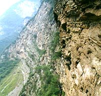
Since the 1980s, highways have been built along the Yangtze River and navigation conditions have naturally improved. The wind eroded the ancient roads, therefore, they are now deserted, except for the odd hiker who sometimes travels across the area. A well-preserved section of the road has also become a remnant of the river recently.
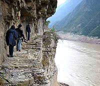
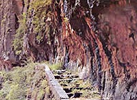
The road, known as the "ancient plank road" that started from Fengjie and ended in Wushan, extended for about 10 km. It used to be a famous scenic spot. On a cliff dozens of meters above the river water, a plank road could be clearly seen, which featured a road created by cutting away part of the stone cliff; a groove road made by chiseling; a stone-piled road and flat bridge to connect the valleys. There were no records about the construction of the road before the Qing Dynasty (1644-1911). After two projects, in the Daoguang and Guangxu reigns of the Qing Dynasty, the road became extremely broad. Boat trackers and sedan carriers could walk on it, shoulder to shoulder. One cannot help sighing to think of how the magic road was developed, with just hammers and chisels.
Qin Jianming, who is responsible for the archaeological investigation of the road, pointed out that the most difficult task was to chisel the rock on the cliff in making the groove road. This kind of road is the most typical and best-preserved plank road in the Three Gorges. The longest section in the Qutang Gorge is 200 meters. What's more, many engineering methods employed in building the road are still in use today, for example: blasting a road with dynamite, digging tunnels and considering flood water levels in deciding the height of a road surface.
Qin thinks that the opening of the road was significant. On the one hand, it started the direct link between Wushan and Fengjie, on the other, it created fine boat tracker roads for the Qutang Gorge, and promoted the development of the shipping industry.
Amazing river road network
The site of the ancient plank road along the Daning River, due to its large scale, construction difficulty, dangerous topography, complete preservation and various unresolved riddles, has become a wonderful place for tourists. It is also an important topic in the archaeological field. Archaeologists feel excited about the cultural value and information of the road.
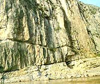
Taking a boat from Wushan, upwards along the Daning River, up on the cliff of the west bank, people will find square stone holes in a customary order. This is all that is left of an ancient plank road. From the Longmen Gorge at the mouth of the Daning River to Ningchang Town of Wuxi County, there are more than 6,800 such holes, each with an area of 6 square cun (about 1/25 square meters), 2 chi (0.67 meter) deep and at a distance of 5 chi (1.67 meters). Except for the main river course down from Ningchang, each branch of the Daning River has similar holes. They are connected with Zhuxi of Hubei Province in the east, Zhenping of Shaanxi Province in the north and Chengkou County in the west, forming a thousand-km-network of plank roads. The large scale is unprecedented.
It can be presumed that the plank roads played an important role in political, military, economic and cultural exchanges in ancient China. However, no history books record when they were built, by whom and what were they used for.
Local legend says: Lu Ban, a legendary master carpenter of the Spring and Autumn Period met with Guanyin (Goddess of Mercy) one day. Seeing the hardship of ordinary people, they decided to do something beneficial for them. So they made a bet: in one night Lu Ban would build a road on the cliff while Guanyin would make a 100 pairs of embroidered shoes. Then, Lu Ban began his work. One knock with his angle square created a hole and he decided the distance apart was to be 5 chi (1.67 meters). Guanyin crept into Lu Ban's place, and finding that he had nearly finished, mimicked the sound of a cock crowing. Hearing the sound, Lu Ban thought the day had broken and stopped working. However, a neat line of stone holes were left.
The legend expressed a simple idea for ordinary people: they could not believe mighty work could be done by man alone.
Road holes follow standard of Qin and Han dynasties
Qin Jianming is responsible for the investigation of the 80-km long ancient plank road. He says he is doing specific archaeological work to collect material related to the road and studying it. He has walked along the road, recording details about the shape, direction and construction of the holes as well as collecting folk tales on them. The bet between Lu Ban and Guanyin is one of his achievements.
Qin said he can feel the unusual determination and courage of the ancient people every time he walks along the road. He thinks the road fully demonstrates the creativity of ancient laborers. It must have been hard to dig so many deep holes on the precipitous cliff with bronze or iron tools that were not very strong. Some of these difficulties are hard to imagine today.
The road which was a major method of transportation often found in rugged mountains, emerged early in China. Historical Records, by Sima Qian of the Western Han Dynasty, said that "The 1,000-li plank road extends to the Kingdom of Shu Han (221-263)," showing the plank road was highly developed even during the Three Kingdoms (220-280). Qin said that the plank road has also been seen in foreign countries. According to Record of Travels to Western Lands, Xuanzang, a Buddhist scholar, translator and traveler of the Tang Dynasty, came across a plank road on his way to India. Holes had been made in cliffs, and those who wanted to get through would be given two wooden stakes. By alternating the wooden stakes into the holes, they could pass, requiring huge courage and strength. Certainly, the plank roads in China were well developed.
The large scale plank road on the Daning River may have been built during the Qin and Han dynasties, because China put great effort into building plank roads then and the size of the stone holes (30 by 30 cm) follow the standard of that period.
Mysteries remain over the plank road
There are many stories about the history and purpose of the plank road, but none can explain its mysteries.
In Ningchang, the northern end of the plank road, there was a natural salt spring. The salt produced there was sold everywhere. The County Annals of Wushan and County Annals of Wuxi recorded differently that the plank road along the Daning River was built during the Tang Dynasty or the Han Dynasty, but with the same aim to channel the salt spring to the Yangtze River by long bamboo pipe. Qin Jianming didn't believe the record because, he said, there was no need to dig huge holes in cliffs and insert bulky logs in them if people were only to divert water. Others thought it unimaginably strange to transport salt water 100 km, for Ningchang County could process the brine itself. Why didn't they carry salt instead of the brine? What's more, Ningchang is located along the river. It could get one ton of salt out by boat. Why should it need men and horses to carry salt out? A more reasonable explanation might be that the plank road was built to track the boats.
Folk legend says the plank road was used during war, for instance, when the Emperor Taizu of the Song Dynasty conquered the Shu, or when Zhang Xianzhong entered Sichuan.
Others say the plank road was developed simply for people to pass. If this were true, one line of holes would be enough to hold wooden boards, but two lines of holes were found in many places. Why? If as someone supposed the upper row was used for a canopy, why was the space between the upper and lower holes not enough for a person to stand erect? What's even stranger is that some holes were dug under the cliff while there was enough space in a comparatively safe place. If people wanted to pass the road, they would need to crawl over. In some other places, a slope had been made ready, but why would people still dig out plank roads on the cliff?
To date, no exact record has been found on how the gigantic project was completed. Qin feels a little proud of himself when talking about this because this is just what he is researching. Archaeological investigation is like solving a criminal case, Qin said. People need to deduce what has happened in order to interpret present traces. It requires thorough knowledge.
The Three Gorges Reservoir has begun storing water. Qin might become the last person to completely survey the Daning River plank road and grasp the most clues to all these mysteries. His research findings are eagerly awaited.
(Beijing Youth Daily translated by Li Jinhui for China.org.cn October 2, 2003)