


China has various landforms, including magnificent plateaus, rolling foothills, vast plains and low-lying highlands, as well as basins of different sizes that are surrounded by hills. All these five basic landforms can all be found in the country, with mountainous areas making up two thirds of its total land area.
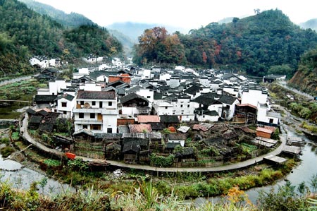 |
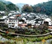
Pictured is the tranquil and beautiful scenery in Wuyuan County, Jiangxi Province.
China has a terraced terrain, which descends from the west to the east step by step. The first, or the highest, terrace is the Qinghai-Tibet Plateau, with an average elevation of over 4,000 meters. The Kunlunshan Mountains, the Qilianshan Mountains and the Hengduanshan Mountains, which are located to the north and east of the plateau, are the division of the first and the second terraces.
 |
The southern region of China, favored by a mild and humid climate, enjoys an extensive water-transportation network. Pictured are croplands in Xinghua in Jiangsu Province in early spring.
The second terrace is made up of large-scale basins and plateaus, averaging 1,000 to 2,000 meters above sea level. The Greater Hinggan Mountains, the Taihangshan Mountains, the Wushan Mountains, the Xuefengshan Mountains in the east are the boundary between the second and third terraces
The third terrace is composed mainly of plains below 200 meters above sea level, dotted with some hills and low mountains.
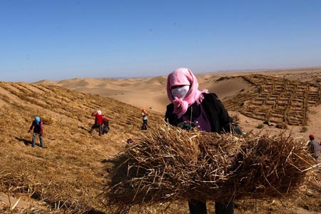 |
China's terrain slopes down from the west to the east and the inland northwestern region is dry and rainless. Pictured is a woman in Gansu Province making sand reinforcement using the dry stalks of wheat.
A topographical section of China along the parallel of 32 degrees north latitude shows clearly that the country's terrain descends step by step from plateaus in the west to basins in the central part then to plains in the east.
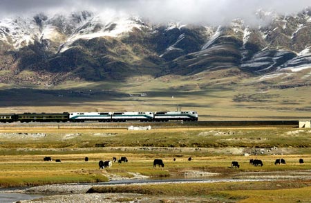 |
Trains are now running across the Qinghai-Tibet Plateau, dubbed the roof of the world, thanks to the opening of the world's highest rail road, Qinghai-Tibet Railway, on July 1, 2006.
The third terrace of China's mainland extends to the sea in the form of sub-littoral zones on the continental shelf, which is the natural extension of the continent. It is not deep, with a grading slope and rich oceanic resources.
Four Major Plateaus
Qinghai-Tibet Plateau Situated in southwest China, it is the largest plateau in China, covering 2.5 million square km, or nearly a quarter of the national total land area. It is also the highest plateau on earth, and is known as the "roof of the world." As it is surrounded and traversed by several snow-capped mountain ranges, like the Kunlunshan, Qilianshan, Hengduanshan and the Himalayas, which abound in glacier, the Qinghai-Tibet Plateau is where many of China's major rivers originate.
Inner Mongolia Plateau The second largest plateau in China, it lies between 1,000 and 1,500 meters above sea level in north China. Covering 700,000 square km, the plateau has a gentle rolling terrain and vast grasslands, with some parts covered with arid Gobi deserts.
Loess Plateau With the Taihangshan Mountains to its east, the Qilianshan Mountains to its west, the Great Wall to its north and the Qinling Mountains to its south, the Loess Plateau covers around 500,000 square km and lies 1,000 to 2,000 meters above sea level. Covered with thick, porous loess, the Loess Plateau is crisscrossed with ravines and gullies, covered with little vegetation, and has fragmented landforms due to long-term scouring of rainfall and streams. Water-eroded area accounts for 430,000 square km.
Yunnan-Guizhou Plateau Covering 500,000 square km, it comprises east Yunnan Province and most parts of Guizhou Province. It has an elevation of 1,000 to 2,000 meters and a terrain that descends from the northwest to the southeast. It is covered with numerous valleys and small basins. Typical Karst topography, shaped by the dissolution of limestone rich in the region, is common on the plateau.
Main Mountain Ranges
Numerous lofty mountains form many mountain systems, which serve as the framework of China's topography. Well-known mountain ranges include the Himalayas, the Kunlunshan Mountains, the Tianshan Mountains, the Qinling Mountains, the Greater Hinggan Mountains, the Taihangshan Mountains, the Qilianshan Mountains and the Hengduanshan Mountains.
Himalayan Mountain Range Extending more than 2,400 km in a crescent-shape along the Chinese-Indian and Chinese-Nepalese borders, it has an average elevation of 6,000 meters. It is the world's highest and largest mountain range, and its main peak, Qomolongma, is 8,844.43 meters above sea level, the highest in the world.
Kunlunshan Mountain Range Extending over 2,500 km from the Pamirs Plateau in the west to the northwest of Sichuan Province in the east, it has an average elevation of 5,000 to 7,000 meters. Its highest peak, Kongur, is 7,719 meters above sea level.
Tianshan Mountain Range Traversing Xinjiang Uygur Autonomous Region, it has an average elevation of 3,000 to 5,000 meters, with its highest peak, Tomur, being 7,455.3 meters above sea level.
Tanggula Mountain Range Situated in central Qinghai-Tibet Plateau, it has an average elevation of 6,000 meters. The Yangtze River rises from its highest peak, Geladaindong, which is 6,621 meters above sea level.
Qinling Mountain Range Stretching from east Gansu Province in the west to the west of Henan Province in the east, it has an average elevation of 2,000 to 3,000 meters. Its main peak, Taibaishan, is 3,767 meters above sea level. It is an important geographic line of demarcation between north and south China.
Greater Hinggan Mountain Range Extending 1,000 km from Mohe of Heilongjiang Province in the north to the upper reaches of Laohahe River at the juncture of Inner Mongolia and Liaoning Province in the south, it has an average elevation of 1,500 meters. Its main peak, Huanggangliang, is 2,029 meters above sea level.
Taihangshan Mountain Range Extending over 400 km along the eastern fringe of the Loess Plateau from north to south, it has an average elevation of 1,500 to 2,000 meters. Its main peak, Xiaowutaishan, is 2,882 meters above sea level.
Qilianshan Mountain Range Stretching along the northeastern fringe of the Qinghai-Tibet Plateau, it has an average elevation of over 4,000 meters. Its main peak, Qilianshan, is 5,547 meters above sea level.
Hengduanshan Mountain Range Situated at the juncture of Tibet, Sichuan and Yunnan in the southeast of the Qinghai-Tibet Plateau, it has an average elevation of 2,000 to 6,000 meters. Its highest peak, Gonggashan, is 7,556 meters above sea level.
Taiwan Mountain Range Running through the eastern part of Taiwan Island, it has an average elevation of 3,000 to 3,500 meters. Its main peak, Yushan, is 3,952 meters above sea level.
Basins
Tarim Basin Situated in the southern part of Xinjiang Uygur Autonomous Region and embraced by the Tianshan and Kunlunshan mountains, it is China's largest basin. With its base averaging 800 to 1,300 meters above sea level, it covers 530,000 square km. The basin, widely covered with deserts and dotted with oasis at the fringe, has a terrain descending from the west to the east. The 330,000-square-km Taklamakan in the center of the basin is the largest and the most arid desert in China, and one of the country's richest areas in oil and gas reserves.
Junggar Basin Situated between the Tianshan and Altay mountains in north Xinjiang Uygur Autonomous Region, it is the second largest basin in China, covering 380,000 square km. With its base averaging 200-1,000 meters above sea level, the basin has a terrain descending from the east to the west, with its central part covered with grasslands and deserts. It abounds in coal and oil reserves.
Qaidam Basin Situated in northwest Qinghai Province in the northeastern part of the Qinghai-Tibet Plateau, the basin is surrounded by the Kunlunshan and Qilianshan mountains. It covers 220,000 square km, with its base averaging 2,700-3,000 meters above sea level. Gobi deserts, hills, plains and lakes are distributed from the fringe to the center of the basin, which has a terrain descending from the northwest to the southeast, where there are a large number of salty lakes and swamps.
Sichuan Basin Situated in the Sichuan-Chongqing area, the basin is surrounded by Wushan and Dabashan mountains and covers 200,000 square km. With its base averaging 300-800 meters above sea level, it has a terrain descending from the north to the south. Its northwestern part is Chengdu Plain, and its central and eastern parts are hills and low mountains. Teeming with purplish red sandstones, it is also known as a "purple basin."
Turpan Basin Situated at the eastern terminus of the Tianshan Mountains in the middle-eastern part of Xinjiang Uygur Autonomous Region, the basin covers 50,000 square km. Aydingkol Lake at its base, lying 155 meters below sea level, is the lowest point of China's mainland.
Plains
Northeast China Plain Situated in northeast China, the plain lies between the Changbaishan Mountains in the east and the Greater Hinggan Mountains in the west and borders on the Lesser Hinggan Mountains in the north and the Liaodong Bay in the north. Covering 350,000 square km, it is China's largest plain. With most of it having an elevation of lower than 200 meters, it embodies the Heilongjiang-Songhuajiang-Wusulijiang Plain, the Songhuajiang-Nenjiang Plain, the watershed between the Songhuajiang and Liaohe rivers and the Liaohe Plain. Therefore, the plain is also called Songliao Plain.
North China Plain Bordering on the Taihangshan Mountains in the west, the coast in the east, the Yanshan Mountains in the north and the Huaihe River in the south, the plain covers 300,000 square km, with an average elevation of lower than 100 meters. Formed of alluvial deposits from the Yellow, Huaihe and Haihe rivers, it is also known as the Yellow River-Huaihe-Haihe Plain. It has a smooth terrain and vast fertile land.
The Middle-Lower Yangtze Plain Stretching eastward from the Wushan Mountain to the coast, the plain was formed of alluvial deposits from the Yangtze River and its tributaries. With an average elevation of lower than 50 meters and part of it lying below 5 meters above sea level, it is generally lower than the North China Plain. Crisscrossed by many rivers and dotted with lakes, it is known as "a swampy region."
Pearl River Delta Plain Situated in the middle-southern part of Guangdong Province, the plain covers 11,000 square km, with an average elevation of around 50 meters. It has crisscrossing rivers and is dotted with isolated hills.
Hetao Plain Lying along the banks of the Yellow River in Inner Mongolia and Ningxia Hui autonomous regions, the plain covers 24,800 square km, with an average elevation of around 1,000 meters. Rich in irrigation facilities, it is known as "the northern frontier resembling the south of the Yangtze."
Rivers, Lakes and Water Resources
China abounds in rivers, lakes and water resources.
Due to its topographical features, most rivers flow east or south into the ocean, thus forming vast outflow river valleys that constitute nearly two thirds of the national total area. Most of them belong to the Pacific Valley and a small number fall into the Indian Ocean Valley. Only the Erix River in Xinjiang Uygur Autonomous Region that flows westerly out of China belongs to the Arctic Ocean Valley.
More than 1,500 rivers have a drainage area of over 1,000 square km. The average annual runoff stands at 2.7 trillion cubic meters, ranking sixth in the world. Holding the top five positions are Brazil, Russia, Canada, the United States and Indonesia. Famous rivers in China include the Yangtze, Yellow, Heilongjiang, Yarlung Zangbo, Pearl and Huaihe rivers. The Tarim River in Xinjiang is the longest inland river in China. This 2,100-km-long river has been known as the "river of life," as it runs across deserts.
Main Rivers
Yangtze River The longest in Asia and the third longest in the world, the Yangtze rises from Geladaindong, the highest peak of the Tanggulashan Mountains. It flows 6,300 km eastward traversing 11 provinces, autonomous regions and municipalities before emptying into the East China Sea, leading other Chinese rivers in terms of drainage area. It has numerous tributaries, including the Yalongjiang, Minjiang, Jialingjiang, Hanjiang, Wujiang, Xiangjiang and Ganjiang rivers, with a combined drainage area of over 1.8 million square km, accounting for 18.8 percent of China's total area. Its annual runoff stands at 951.3 billion cubic meters, accounting for 52 percent of the national total. It is a major artery of inland water transportation in China.
Flowing easterly from Fengjie County, Chongqing Municipality, to Yichang City, Hubei Province, the Yangtze cuts across the Wushan Mountain, forming three gorges with a total length of 193 km. The famous Three Gorges Water Project began construction at the eastern section of the area in 1994. After completion in 2009, the project is expected to be able to control catastrophic flooding that occurs once in a century. It is also expected to annually generate 84.7 billion kwh of electricity, improve navigation conditions, and ensure water supply in urban areas and irrigation of farmland in the middle and lower reaches of the Yangtze River.
Yellow River The second longest in China, it originates from the northern foot of Bayan Har Mountains in Qinghai Province. It flows 5,464 km easterly across nine provinces and autonomous regions before emptying into the Bohai Sea. With a drainage area of more than 750,000 square km, its annual runoff is 66.1 billion cubic meters. It has more than 40 tributaries, of which the Fenhe and Weihe rivers are the largest.
The middle section of the river traverses the Loess Plateau with loose soils, making it a river with highest silt content in the world. Around a quarter of the total silt it carries is deposited at downstream riverbeds, making them rise 10 cm a year on average. Thus, the riverbed of many downstream sections of the river is 3 to 5 meters higher than the surrounding land.
The upstream of the Yellow River runs through the junction of the country's first- and second-terrace regions, a section reserving most waterpower resources of the river. Many water conservancy projects have been built in this area, including those at Longyangxia, Liujiaxia and Qingtongxia.
Heilongjiang River Situated in the northernmost part of China, it is the boundary river between China and Russia. Its mainstream flows 3,420 km within the boundaries of China, with a drainage area of around 900,000 square km.
Yarlung Zangbo River Originated from glacier north of the Himalayas in Gampa, Tibet, it flows 2,057 km and covers a drainage area of 240,480 square km. The river is the highest one in the world, with an average altitude of 4,500 meters above sea level. It is called Brahmaputra River when cutting into India at the northern border of Arunachal Pradesh.
Pearl River The largest in south China, it flows 2,214 km, with a drainage area of 453,690 square km and an annual runoff of 333.8 billion cubic meters. In terms of runoff volume, it is considered the second largest in China, next to the Yangtze River.
Huaihe River It flows 1,000 km, with a drainage area of 269,283 square km and an annual runoff of 62.2 billion cubic meters.
Songhuajiang River It flows 2,308 km, with a drainage area of 557,180 square km and an annual runoff of 76.2 billion cubic meters.
Liaohe River It flows 1,390 km, with a drainage area of 228,900 square km and an annual runoff of 14.8 billion cubic meters.
Beijing-Hangzhou Grand Canal Starting from Beijing's Tongzhou District in the north, the canal extends 1,800 km to Hangzhou, Zhejiang Province in the south. Flowing through Beijing, Tianjin, Hebei, Shandong, Jiangsu and Zhejiang, it connects the Haihe, Yellow, Huaihe, Yangtze and Qiantangjiang rivers. First dug in the 5th century B.C., the canal served as an important channel for the transport of grain in ancient China. The earliest and longest artificial waterway in the world, its southern section is still navigable.
Lakes
China has numerous lakes. More than 2,800 natural lakes have a surface area of over 1 square km, and some 130 lakes cover more than 100 square km. There are also a large number of artificial lakes (reservoirs). With different salt content, the lakes are classified into saltwater and freshwater lakes. Large lakes are mainly distributed in the middle and lower reaches of the Yangtze River and on the Qinghai-Tibet Plateau. The Poyang Lake, situated south of the Yangtze River in the northern part of Jiangxi Province, is the largest freshwater lake in China while the Qinghai Lake on the Qinghai-Tibet Plateau is the largest saltwater lake.
Main Lakes in China
|
Name |
Location |
Area (sq. km) |
Elevation of lake surface (meter) |
Water storage capacity ( |
Depth (meter) |
Water quality |
|
|
|
4,535 |
3,196 |
854.4 |
28.7 |
Saltwater |
|
|
|
3,583 |
21 |
248.9 |
16 |
Freshwater |
|
|
|
2,740 |
33.5 |
178.0 |
30.8 |
Freshwater |
|
|
|
2,420 |
3.14 |
48.7 |
4.8 |
Freshwater |
|
Hulun Nur |
|
2,315 |
545.5 |
131.3 |
8 |
Freshwater |
|
|
|
2,069 |
12.25 |
33.3 |
5.5 |
Freshwater |
|
Nam Co |
|
1,940 |
4,718 |
768.0 |
35 |
Saltwater |
|
|
|
1,268 |
34 |
25.3 |
6 |
Freshwater |
|
|
Xinjiang |
1,019 |
1,048 |
99.0 |
15.7 |
Freshwater |
|
|
|
820 |
10 |
36.0 |
5 |
Freshwater |