


According to the Constitution of the People's Republic of China, the administrative division of China is as follows:
1. The country is divided into provinces, autonomous regions and municipalities directly under the Central Government;
2. Provinces and autonomous regions are divided into autonomous prefectures, counties, autonomous counties and cities; and
3. Counties and autonomous counties are divided into townships, ethnic townships and towns.
Municipalities directly under the Central Government and other large cities are divided into districts and counties. Autonomous prefectures are divided into counties, autonomous counties and cities.
All autonomous regions, autonomous prefectures and autonomous counties are ethnic autonomous areas.
The state may establish special administrative regions when necessary.
Currently, there are 34 provincial-level administrative areas in China—four municipalities directly under the Central Government, 23 provinces, five autonomous regions and two special administrative regions.
Municipalities Directly Under the Central Government
Beijing Called "Jing" for short, Beijing is located at the northwestern end of the North China Plain. It was established as a municipality in 1928. Covering an area of 16,800 square km, Beijing is now a municipality directly under the Central Government, and has under its jurisdiction 16 districts and two counties. Statistics (provided by public security departments) show that Beijing's permanent residents (referring to those living for more than half a year in Beijing) totaled 15.81 million at the end of 2006 and its registered permanent residents stood at 11.976 million, up 430,000 and 169,000 year on year, respectively.
 |
Beijing is China's center of politics, culture, science and education as well as a hub of transportation. It also boasts a large number of tourist attractions.
Beijing is China's political, cultural, scientific and educational center as well as a hub of communications. It is also a world-famous tourist destination, with many places of historic interest and scenic spots, including the Palace Museum, the Temple of Heaven, the Great Wall, the Ming Tombs, the Summer Palace and the Fragrant Hill.
Shanghai Called "Hu" for short, Shanghai is located at the estuary of the Yangtze River in the middle section of China's eastern coast and became a city in 1927. One of China's four municipalities directly under the Central Government, Shanghai, covering 6,340.5 square km, has under its jurisdiction 18 districts and one county. Its registered permanent residents totaled 13.681 million, with permanent residents standing at 18.15 million at the end of 2006.
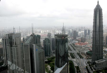 |
Shanghai is one of the four municipalities directly under the Central Government, known for its burgeoning economy.
Shanghai is the largest city in China and one of the major metropolises in the world. It is also the country's top industrial city, commercial and financial center, as well as a scientific and technological base.
Tianjin Called "Jin" for short, Tianjin is located in the northeast of the North China Plain, where the five major tributaries of the Haihe River converge and empty into the Bohai Sea. It became a city in 1928. Covering an area of 11,900 square km, Tianjin is now a municipality directly under the Central Government, having 15 districts and three counties under its jurisdiction. Its permanent population was 10.75 million at the end of 2006, including 9.4888 million registered residents.
Tianjin is China's largest industrial city, a major commercial center and a port in north China. Famous scenic spots and historical sites in Tianjin include Ningyuan Park, Tianhougong Temple, Dagukou Batteries, Dule Temple (Monastery of Solitary Happiness) in Jixian County, the Huangyaguan section of the Great Wall and Panshan Mountain.
Chongqing Called "Yu" for short, Chongqing is located on the upper reaches of the Yangtze River on the eastern part of southwest China. Chongqing was designated as a municipality directly under the Central Government in 1997. It has under its jurisdiction 15 districts, four county-level cities, 17 counties and four autonomous counties. Covering 82,300 square km, its permanent population stood at 28.08 million, including 13,1129 million urban residents at the end of 2006.
Chongqing is also an industrial city and a tourist destination. Its famous scenic spots include Pipashan and Jinyunshan mountains and the scenic area along the Chuanjiang River.
Provinces and Autonomous Regions
Hebei Province Called "Ji" for short, Hebei is in north China, on the coast of the Bohai Sea. Surrounding Beijing and close to Tianjin, Hebei covers 187,700 square km, with a population of 68.978 million at the end of 2006. Shijiazhuang is the provincial capital.
Shanxi Province Called "Jin" for short, Shanxi is located west of the Taihangshan Mountain in north China. It covers 156,000 square km, with a population of 33.746 million at the end of 2006. Taiyuan is the provincial capital.
Inner Mongolia Autonomous Region Called "Inner Mongolia" for short, the region is on the northern frontier of China, bordered by Mongolia and Russia on the north. It covers 1.1975 million square km, with a population of 23.9235 million at the end of 2006, including 4.2383 million Mongolians. Hohhot is the regional capital.
Liaoning Province Called "Liao" for short, Liaoning is located in the southern part of northeast China and faces the Yellow Sea and the Bohai Sea on the south, with the Democratic People's Republic of Korea to its east. It covers 145,900 square km, with a population of 42.23 million at the end of 2006. Shenyang is the provincial capital.
Jilin Province Called "Ji" for short, Jilin lies in the middle of northeast China, bordered by Russia and the Democratic People's Republic of Korea on the southeast. It covers 187,400 square km, with a population of 27.23 million at the end of 2006, representing a year-on-year increase of 70,000. Changchun is the provincial capital.
Heilongjiang Province Called "Hei" for short, Heilongjiang lies to the northernmost part of northeast China, adjoining Russia on the east and north. It covers more than 460,000 square km, with a population of 38.23 million at the end of 2006. Harbin is the provincial capital.
Jiangsu Province Called "Su" for short, Jiangsu is located on the lower reaches of the Yangtze River and the Huaihe River along the coast of the Yellow Sea. It covers 102,600 square km, with a permanent population of 75.495 million at the end of 2006, representing a year-on-year increase of 750,000. Nanjing is the provincial capital.
Zhejiang Province Called "Zhe" for short, Zhejiang in east China lies along the coast of the East China Sea. It covers 101,800 square km, with a permanent population of 49.8 million at the end of 2006. The province's total coastline stretches 6,486 km, the longest in China. Among the province's many islands, 3,061 have a land area of 500 square meters or more. Hangzhou is the provincial capital.
Anhui Province Called "Wan" for short, Anhui lies to the northwest of east China, with both the Yangtze River and Huaihe River crossing it. It covers 139,600 square km and has a registered permanent population of 65.935 million at the end of 2006. The province's urbanization rate was 35.5 percent in the year. Hefei is the provincial capital.
Fujian Province Called "Min" for short, Fujian on the southeastern coast of China, faces Taiwan Province across the sea. Its territory includes 121,400 square km of land and 136,300 square km of sea. Its coastline stretches 3,324 km, the second longest in the country. Its permanent population stood at 35.58 million at the end of 2006. Fuzhou is the provincial capital.
 |
Xiamen is a scenic coastal city in southeast China.
Jiangxi Province Called "Gan" for short, Jiangxi is located south of the middle and lower reaches of the Yangtze River. It covers 166,900 square km, with a population of 43.3913 million at the end of 2006. Nanchang is the provincial capital.
Shandong Province Called "Lu" for short, Shandong sits on the lower reaches of the Yellow River, bordering the Yellow Sea and the Bohai Sea. It covers 156,700 square km, with a population of 93.09 million at the end of 2006. Jinan is the provincial capital.
Henan Province Called "Yu" for short, Henan, which comprised the major part of the Central Plains in ancient China, is located on the middle and lower reaches of the Yellow River. It covers 167,000 square km, with a population of 98.2 million at the end of 2006. Zhengzhou is the provincial capital.
Hubei Province Called "E" for short, Hubei lies north of Dongtinghu Lake on the middle reaches of the Yangtze River. It covers 185,900 square km, with a population of 60.5 million at the end of 2006, including 56.93 million permanent residents. Wuhan is the provincial capital.
 |
A bird's eye of Zigui County in Hubei Province.
Hunan Province Called "Xiang" for short, Hunan is located south of Dongtinghu Lake, along the southern banks on the middle reaches of the Yangtze River. It covers 211,800 square km, with a population of 67.681 million at the end of 2006. Changsha is the provincial capital.
Guangdong Province Called "Yue" for short, Guangdong lies south of the Nanling Mountains, along the coast of the South China Sea. It covers 178,000 square km, with a permanent population of 93.04 million at the end of 2006. Guangzhou is the provincial capital.
Guangxi Zhuang Autonomous Region Called "Gui" for short, Guangxi lies to the western part of south China, faces Beibu Gulf on the south and adjoins Viet Nam on the southwest. It covers 237,700 square km, with a population of 49.61 million at the end of 2006. Nanning is the regional capital.
Hainan Province Called "Qiong" for short, the province encompassing the Hainan Island, and the Xisha, Nansha and Zhongsha Islands and the surrounding seas, covers a land area of 35,000 square km and a sea area of approximately 2 million square km. Hainan Island is China's second largest island after Taiwan, with an area of 33,900 square km. Zengmu Shoal of Nansha Archipelago is the southernmost part of Chinese territory. Its permanent population stood at 8.3588 million at the end of 2006. Haikou is the provincial capital.
Sichuan Province Called "Chuan" or "Shu" for short, Sichuan is located on the upper reaches of the Yangtze River in the southwest of China. It covers 485,000 square km, with a population of 81.69 million at the end of 2006. Chengdu is the provincial capital.
Guizhou Province Called "Qian" or "Gui" for short, Guizhou lies to the east of the Yunnan-Guizhou Plateau, southwest China. It covers 176,100 square km, with a population of 39.553 million at the end of 2006, representing a year-on-year increase of 241,800. Guiyang is the provincial capital.
Yunnan Province Called "Dian" or "Yun" for short, Yunnan on the southwestern frontier of China is bordered by Myanmar, Laos and Viet Nam. It covers 394,000 square km, with a population of 44.81 million at the end of 2006. Kunming is the provincial capital.
Tibet Autonomous Region Called "Zang" for short, Tibet lies on the Qinghai-Tibet Plateau on the southwestern border of China, adjacent to India, Nepal, Bhutan and Myanmar. It covers 1.2749 million square km. Its total population stood at 2.81 million at the end of 2006, a year-on-year increase of 40,000. Lhasa is the regional capital.
Shaanxi Province Called "Shaan" or "Qin" for short, Shaanxi is located on the middle reaches of the Yellow River. It covers 205,600 square km, with a population of 37.3505 million at the end of 2006. Xi'an is the provincial capital.
Gansu Province Called "Gan" or "Long" for short, Gansu is located on the middle reaches of the Yellow River in northwest China, with its northwestern part adjacent to Mongolia. It covers 454,400 square km, with a population of 25.9436 million at the end of 2006. Lanzhou is the provincial capital.
Qinghai Province Called "Qing" for short, Qinghai is located on the upper reaches of the Yangtze and Yellow rivers in west China. It covers 721,200 square km, with a population of 5.477 million at the end of 2006. Xining is the provincial capital.
Ningxia Hui Autonomous Region Called "Ning" for short, Ningxia is located on the middle reaches of the Yellow River in the northwest of China. It covers 62,800 square km, with a population of 6.0373 million at the end of 2006. Yinchuan is the regional capital.
Xinjiang Uygur Autonomous Region Called "Xin" for short, Xinjiang lies to the northwestern border of China, adjacent to Mongolia, Russia, Kazakhstan, Kyrgyzstan, Tajikistan, Afghanistan, Pakistan and India. Covering an area of 1.6558 million square km, Xinjiang is the largest of all Chinese provinces and autonomous regions, with a population of 20.5 million at the end of 2006. Urumqi is the regional capital.
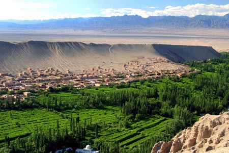 |
The Grape Valley on the northeastern outskirt of the Turpan City in Xinjiang Uygur Autonomous Region is a renowned oasis in a seemingly endless desert.
Taiwan Province Called "Tai" for short, Taiwan is located on the continental shelf off the southeastern coast of China's mainland. It is the largest island of China, covering 36,188 square km. The Taiwan Province consists of the Taiwan Island of 35,873 square km, 21 adjunct islands and the 64 islets of Penghu Archipelago. According to the statistics provided by the relevant authorities of Taiwan, the province had a population of 22.877 million at the end of 2006. Taipei is the provincial capital.
 |
A street view of Taipei, Taiwan.
Special Administrative Regions
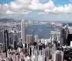
Hong Kong Special Administrative Region Called "Gang" for short, it comprises Hong Kong Island, Kowloon, the New Territories and neighboring islands and covers 1,103.72 square km. According to the statistics provided by the Census and Statistics Department of the Hong Kong Special Administrative Regional Government, at the end of 2006, the region had a population of 6.8571 million.
 |
Hong Kong is one of the most dynamic economies in the Asia-Pacific region.
Macao Special Administrative Region Called "Ao" for short, Macao is located on a peninsula on the western banks of the Pearl River estuary. Including Taipa and Coloane islands, it covers 27.3 square km. The number of Macao's residents was 513,427 as of December 31, 2006.
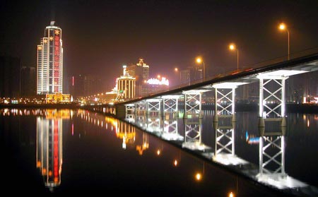 |
Macao is brilliantly illuminated in night.