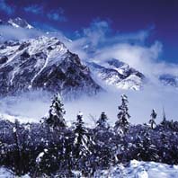
 Most of the world's highest mountains are clustered along the barren, jagged area where Tibet, Nepal, and Pakistan meet, but Gongga Shan -- in China's western Sichuan province -- stands apart. A Western mountaineering team first reached its summit in 1935, and a Chinese team made the climb in the 1950s. The last team to attempt it perished in an avalanche.
This area of Sichuan, the Garze Tibetan Autonomous Prefecture, is a far cry from the areas of Sichuan to which Western travelers are accustomed. The same dense vegetation seen throughout the province is here, but less stained by pollution. The hills throughout Sichuan that distinguish the region rise up here into mountains that soar higher than fog allows you to see. The peaks here are higher, the ravines deeper, the rivers louder, the fog thicker, and the vegetation greener and even more lush -- here is a Sichuan that has exploded from the lowlands and been magnified by its elevation. Classical Chinese artists that painted cliffs thousands of meters high, and fast moving, turbulent rivers were probably inspired by this region.
The Hailuogou glacier rests in the valley that stretches down from Gongga Shan. Sharing the valley with the glacier are dozens of protected plant and animal species. For roughly 1,600 years this ice wall has been creeping and carving its way down to the forests below towards Moxi, grinding down trees and breaking rocks. The river Dadu, created by glacial melt, continues to alter the landscape further down the valley.
A trip to Hailuogou begins in Chengdu, Sichuan's capital. At Xinanmen bus station my girlfriend Felicia and I bought two bus tickets for 150 yuan apiece, which included an unexpected, and compulsory, insurance policy for traveling in Hailougou. Our bus departed from Chengdu Xinanmen at 16:00. We were due to arrive in Luding the following day at around 06:00, and continue on another bus leaving at 08:00.
We arrived in Ya'an, a half-asleep industrial town, two and a half hours later, for a dinner stop, and fell into conversation with an American couple. They explained where the compulsory insurance policy came from: some years back a Japanese tourist had died while travelling. His family sued the Chinese government, and Westerners are now obliged to pay for insurance.
After two hours in Ya'an we were anxious to leave. One passenger we asked said the bus would depart at 06:00 the following day, and so did the second. We then asked the bus driver. Apparently the ride to Kangding can be as short as 8 hours, but ours would not be.
We got a room at the Jiaotong bus station hotel. The people running the station hotel were exceptionally nice. We joked and laughed with them and they recommended a few places for us to eat.
We woke at 05:00. It was raining heavily and as we walked downstairs with packs on our backs, we came to a gray lake at the bottom of the staircase. We didn't know how deep it was -- 6 inches? 2 feet? None of us wanted to be the first to find out.
The water extended out from the hallway into the parking lot, which we began to wade through. Then I stepped into nothing, or rather, a big drainage ditch indiscernible beneath the water. I fell, with my pack on, first coming down on my left knee, and then splashing the rest of the way in.
The first thing that hit me was the cold. That nasty, brackish, gray, water was like icy Jell-O. If you ever have to walk this stretch in the rain, follow someone else's footsteps.The bus driver started the engine as I was pulling my boots off and pouring liquid out of them. I pulled myself onto the top bunk of the bus, lit a cigarette and cracked the window.
After a rest stop at a military barracks we finally reached the mouth of the Erlang pass. It was considerably colder than Ya'an , or seemed so to me as I was soaking wet. The bus pulled up behind a line of Russian and Chinese made trucks that stretched ahead of us on a road that wound in and out of view along the edge of the hills. The fog was thick -- no surprise -- but the landscape was rougher and more threatening, like a Constable painting that had been stretched, so its lines were sharper, and the smudgy detail more elongated and dangerous looking.
The Erlang pass is open for traffic in one direction at a time. Every twelve hours it reverses, and it is the other side's turn to wait. The driver had timed it so that we arrived about two hours before our line was due to move. Peddlers walked along the road, hawking noodles and walnuts and peppers and sodas. Small restaurants enclosed in the red, white and blue awning one sees everywhere in China sold dishes that were elaborate, considering the location. I walked up the row of trucks, soaked and shivering. While passing two PLA men I heard a rumble, looked up fast and panicked, as did everyone around me. A rock landed down the road with an unimpressive thump and we walked over to it. The PLA men laughed and about six trucks started their engines and moved up and further towards the brow of the hill.
The rock was small. It weighed about 250 kilograms. I thought about what demage it could have done to me and headed back to the bus.
At 12:00 engines started up and down the line and we all let out a cheer as the bus lurched forward. The entire line of trucks waiting to cross the Erlang moved forward in fits and starts as we climbed higher and higher. The fog cleared as we moved along and we were rewarded with views down to small river towns thousands of feet below. The bus often came within six inches of the edge, and you could look down at the turbulent white and grey river surging along below. We drove past massive construction projects, with earthmovers and workers' barracks pitched at the side of the road. The construction work on this road never stops, and the repairs to damage caused by crumbling cliff sides account for much of it.
We arrived in Luding at 14:00 -- 22 hours after we had left Chengdu. The distance covered was roughly 290 kilometers.
The ride to Kangding climbed in altitude again. We passed the Luding Bridge, which comprised several chains and planks stretched across the broad Dadu river. Mao and his fellows had crossed the Dadu during the Long March. They moved across the rotten planks hanging from the chains as a small Guomindang force tried to shoot them down into the river. Mao's band, inured to suffering after their months-long running war, won the battle. The Catholic church in Luding had been set up in the 1920s by French missionaries. According to legend, when the Long Marchers stayed here the local priest converted to communism and left with them.
The road continued to elevate, and on it we could see the remains of old rock slides that had taken out small sections of road and dumped them thousands of feet below.
Kangding was another three hours -- by slow, SLOW moving bus. We walked out of the bus station with a Polish professor and headed into the town, following the river Zhedou, a rapid churning mass of water. We passed monks that smiled at us, Tibetan Khampas, piles of yak skulls, and young Han tourists buying knives from souvenir shops. Another church, also established by the French, is here; it looks like a wedding cake.
Kangding sits at 2500 meters above sea level in a narrow valley carved out by the river Zhedou. Kangding is dwarfed by Paoma Shan, but clouds prevented us from seeing it. Kangding is similar to Zermatt in Switzerland, but without the rich skiers. The language here is Tibetan, and Sichuanhua is far from standard Mandarin. Kangding has the feel of an old frontier town; it sits on an ethnolinguistic boundary separating the Han from the Tibetans.
We left the professor in the Black Tent Guesthouse (17- 30 yuan for a dorm bed, extra for an electric blanket) and headed to an hotel 100 meters up the road to the right. A doorman ushered us in. On the wall behind the reception desk were several different clocks showing times in New York, London and Tokyo. To me, this is an international symbol of an hotel too expensive for me. After some bargaining, dormitory beds were available at 30 yuan per person.
We took a taxi from a parking lot along the Kangding main street with 3 other people, including a PLA officer, for the 40 minute drive to Luding. Once there we switched cars and headed to Moxi (traveling from Kangding to Moxi, you pass through Luding). The ride cost 30 yuan per person (from Kangding, 49 km), but the driver added a disclaimer -- the road was probably out.
We crossed a short, modern suspension bridge and soon stopped at another line of traffic. There was a rockslide ahead, and it looked like we were going to be disappointed. Our fellow passenger, a friendly Moxi resident, said he would lead us to Moxi by another route. We drove about 400 meters back down the road and walked down a steep incline. It was a rocky, crumbling, zigzag trail down towards a ravine. After 10 minutes we arrived at a bridge constructed of rusted cables and waterlogged wood. It was about 50 meters in length and hung hundreds of meters above another glacial river. The boards were laid out haphazardly and had three or more inches of daylight between them.
From the other side it was another 45 minutes to the road along a narrow trail. On one side was the cliff wall and on the other, a fast drop into water. We rounded a corner and saw in front of us on the other side of the river the slide -- a jagged indent of raw earth, dirt and rock, about 30 meters across. Chunks of cliff wall were breaking off, crumbling and falling into the torrent below. Bigger rocks moved as well, and there seemed to be more coming down every second. I was fascinated, and looked ahead to see our guide's reaction: he was running. Two seconds before he had been next to me, and now he was tearing ahead.
I was impressed by how fast he moved. Then Felicia started running too, and I finally got the point.
We ran until our lungs gave out, crossed another creaky bridge, and soon reached the road to Moxi. Another shared taxi got us into town for 3 yuan apiece. Moxi is another one-street town, and that one street is lined with restaurants, shops, vans offering transport back down to Moxi, and hopeful motorcycle taxi drivers (30 yuan to Camp three, one way). The rockslide temporarily halted Moxi's tourist economy. Hotels were empty, and the young Han motorcycle taxi drivers idled along the main road.
We bought two passes to the Hailougou Glacier Park for 60 yuan apiece and began the walk, on a concrete road, down to a construction site before starting up the hill again on the winding road to Camp One. This road followed the Moxi River all the way to its preliminary trickle at the top of the 30.7 km-long valley. The Moxi River is a tributary of the Dadu. After a fast elevation gain it was several hundred meters below us. From the road you could see an overturned truck in the river; one of the "guardrails" on the road had been removed as well. This road is the only trail you can take now; increased tourism has resulted in the paving and widening of what was once a footpath.
The walk took four hours, past small snack stands and more fields. People offered to rent us horses (though this is rare now) or transport us by motorcycle. We passed more construction sites, pigpens, cornfields, and finally arrived at the area called Camp One, where a park attendant checked our passes. Camp one stands at 1,940 meters; a hotel was under construction, and is probably open now.
After a night in the dormitory at a nameless pen with an exorbitant cafeteria, we woke at 6 and started towards the next camp. Camp Two, at 2,620 meters, is roughly 3 hours on foot, following yet another winding concrete road prone to frequent small rock falls. It is also an expensive place, with a good baijiu bar that caters to the tourists that ride buses up to the hot springs there. The springs have an average temperature of 80 degrees Celsius. The hot water cascades down rocks into a tributary of the Moxi River. The water collects in warm pools in the rocks and the charge for bathing there is 55 yuan.
The scenery grows more and more beautiful, green, dense and tranquil as you gain elevation. After leaving Camp Two we passed a small lake with horses beside it and a tree growing on top of a boulder that stood 10 or so meters high, near the"Parasitic tree" placard. As you gain elevation the fog becomes thicker and you hope to get high enough to be above it but this, frankly, is rare.
Camp Three lies at 2,940 meters. The Chinese Academy of Sciences maintains an ecological station there, as does a hotel that charges about 600 yuan per night. From here it is another hour's walk through a giant construction site that is probably a parking lot by now, to the glacier viewing stand. Several beautifully constructed bamboo walkways make this last stretch pretty easy, and if you are lazy you can hire porters to transport you and your bags up.
At the viewing station we looked out and saw... clouds. It was deadly quiet, with the occasional crackle of ice from somewhere far up in the glacier's firn basin. Another 15 minutes past the station lies Camp Four, a small, wooden structure that sells Chinese hot-dogs, noodles, tea, beer, and hot water. The water has a price on it because it must be transported up. Beds are available here for 50 yuan; bring your own sleeping bag. If you don't have one, the proprietors might lend you a PLA coat.
At Camp Four the fog finally lifted, just enough to see an ungodly landscape of crushed rock, mud, and ice -- one massive glacial field that stretches out and disappears back into the clouds. This is Hailougou, China's easternmost glacier; a 1,600-year-old sheet of smashed ice. At the section first seen at Camp Four you are close to the end of the glacier, which stretches 14.7 km down from the slopes of Gongga Shan. The ice extends 6 km into the forests below, and finally tapers out near Camp Three. At its end lies a popular ice cave. Higher up the ice thickens, and at its densest the glacier is 200 meters thick.
It is a short walk down into this amazing landscape. On the side are rock formations that have been smoothed and ground by ice for millennia. The glacier is run through with splits, holes, crevasses, and rivers that disappear down one hole to pop up again hundreds of meters away. Everywhere is shattered rock and bluish ice, snow and mud. We walked out onto the ice and saw a group of Han tourists kicking rocks down a big hole. We wandered along the glacier's fringes while they set out across it; soon they were just moving specks. There might still be a trail here, leading down to somewhere near Camp One, but traces of it from the top were gone.
Somewhere above this portion of the glacier lies the real glacier number one, past the ice fall at 6,214 meters. Up there the whole valley is ice, hundreds of meters thick. The ice fall is 1100 meters wide; you can hear the ice breaking away from it most of the day. Further ahead lies Gongga Shan, at 7,556 meters. We went no further and we couldn't see this colossus. It was buried in fog and rain, but had a presence just the same.
Keep in mind that you cannot easily arrange transport from the top back down into Moxi, especially when the road is out. Many of the tourists coming to Hailougou will only take the bus or motorcycle and when the road to Luding is knocked out -- a common occurrence -- this signals a day off. We walked down to Camp Two before hitching a ride with a group of construction workers on their way back to Moxi. They were in a convival mood, laughing, joking, sharing cigarettes and cursing.
Some guidebooks maintain that Hailuogou can be seen in a day, on foot. This is a lie. From Moxi to the fourth camp and back would easily take over 15 hours.
In Moxi we wanted to keep going, straight back to Luding, but transportation stops after 17:00. We were approached by a kid offering us accommodation for 10 yuan apiece. Further down the road we stopped at another hotel, the Moxi Guesthouse, a modern affair with a courtyard. A kind old man convinced us to look at a room, and we saw that it had a water heater in the bathroom. The room cost 160 yuan a night. It was worth it. Dorm beds were also available.
The next day was a relatively easy ride back to Kangding, where we caught a bus back to Chengdu. The tickets cost 110 yuan apiece; hustlers try to drag you onto their bus for the ride.
The ride into Chengdu departed at 17:00. At Luding the buses waited for an hour or so while all the buses back in Kangding filled up and drove down. We set out as a convoy of four vehicles and got as far as the beginning of the Erlang pass before having to take an alternate route, as the pass was closed. We drove until 03:00, when we arrived at another long line of cars and trucks. At 12:30 the next day we began moving again, on a winding, ill- maintained road. After several stops for rock slides we arrived back in Ya'an for a dinner break, and then back to Chengdu. We arrived at Xinanmen station at 19:00.
If you are considering this trip, from Moxi it is better to start your walk up the valley early in the morning. Sleep at Camp Four, and explore the glacier the next morning. Bring rain gear and good footwear.
(China Today January 23, 2003)
|