In its October issue, the Chinese National Geography magazine announced the results of its search for the "Most Beautiful Places in China," including a list of Top Ten Mountains that has caused some controversy.
Of China's traditional "Five Sacred Mountains," only Mount Tai (Shandong) made it into the Top Ten, the rest of which were: Mt. Namjagbarwa (Tibet), Mt. Gongga (Sichuan), Mt. Qomolangma (Tibet), Meili Snow Mountain (Yunnan), Mount Huangshan (Anhui), Daocheng Sacred Peaks (Sichuan), Mount Chogori (Xinjiang), The Kangrinboqe Peak (Tibet) and Mount Emei (Sichuan).
The selection process involved two panels, one of experts and one of media organizations as well as readers' SMS voting, and took nearly half a year. They voted on 15 categories for lakes, glaciers, waterfalls and grasslands and mountains.
A Chinese National Geography editor told Xinhua on October 8 that the state of the natural environment was a key factor in selections. Experts cast their votes on the mountains according to a whole range of criteria including: height, the surrounding environment and ecosystem and scientific interest. Most important was how much people could enjoy them, no matter how famous or how popular they were.
Hu Hongping, a graduate from Fudan University's Chinese Literature Department, said she was not surprised by the exclusion of some famous mountains like Mount Lushan since the natural scenery had been ruined through overexploitation, though many regretted that Mount Huashan wasn't on the list.
An official from Mount Huashan Administration told San Qin Urban Press on October 10 that he couldn't accept the result and didn't believe it could represent the views of the whole nation, but Chinese National Geography said it was environmental problems that made Mount Huashan lose votes.
The results may reflect a change in people's tastes; many of the places selected are in western China and are not well known by many.
Mt. Namjagbarwa in the southeast of Tibet Autonomous Region, the highest peak in the eastern section of the Himalayas, is the world's only unconquered peak above 7,500 meters. The mountain stands 7,788 meters above sea level, capped all year round with a transparent sheet of ice and snow, and is hard to view because it is constantly encircled in fog. Once in a while, the apex of the mountain peeks out from the mist, so it is nicknamed "shy girl." There are three huge valley glaciers between Namjagbarwa Peak and Naipeng Peak to the south that reach down to the green and immense forest.

The Mountain Minya Gongga stands on the borders of Kangding, Luding and Jiulong counties, 7,556 meters above sea level. It is the highest mountain in Sichuan and the 11th highest in the world. Around the summit, in area of 292 square kilometers, there are 145 ice peaks whose altitudes are above 5,000 meters and 110 glaciers of various sizes. The top of Gongga is hidden in cloud almost all year round and it possesses virgin forests, snow mountains, grassland, lakes, hot springs, waterfalls and is worshipped by the locals as a supreme holy mountain.

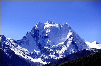
Mt. Qomolangma, also known as Everest, is the highest mountain in the world and stands among the jagged landscape of the Himalayas on the border of Tibet and Nepal. The seemingly pyramidal shape of the 8,844.43-meter mountain dominates the center of the scene if viewed from south. The northeast side of this majestic mountain rises steeply without break for 3,600 meters. Like the other peaks at this high altitude, Qomolangma has been carved by glaciers that move under their own weight. The resulting sharp peaks, steep walls, and U-shaped valleys characterize the almost surreal landscape. Glaciers at the base of these peaks seem to snake down every possible valley. While numerous attempts to reach its summit were made between 1921 and 1952, it was not until May 29, 1953 that Tenzing Norgay and Edmund Hillary finally succeeded.

Meili Snow Mountain is located about 10 kilometers west of Deqing City in Diqing Prefecture, Yunnan Province. As the sun rises in the east, the snow-mountain looks splendid draped in gold. This scene is described in a book named The Lost Horizon. Low-altitude modern glaciers can be found in this area, of particular interest to those engaged in geological research. Under Kawageber Peak, Mingyuchia and Sichia glaciers stretch down to the forest at an elevation of 2,700 meters; this area is accessible. However, Kawageber Peak, the highest at 6,740 meters above sea level, is still a "virgin peak" untouched till now. Meili Snow Mountain is the highest holy Tibetan Mountain in the world, shrouded in mist, cloud and mystery.

Located in the southern part of Anhui Province, Mount Huangshan extends across four counties -- Shexian, Yixian, Taiping, and Xining. Within an area of 154 square kilometers there is a crowd of peaks, 72 of which have names indicating the shapes they resemble, and when it is cloudy the pinnacles loom in mists. Together with the Yellow River, the Yangtze River and the Great Wall, Mount Huangshan has become one of the great symbols of China. It can boast of abundant resources and great variety of zoological species, for which it has been listed as a World Natural and Cultural Heritage site.
Daocheng Sacred Peaks, the "Heavenly Charms in the Snow World" well-known among Tibetans, consist of three snow peaks whose names were, according to a legend, conferred by Dalae V. Xiannairi: the 6,032-meter north peak, means Avalokiteshvara, the Buddhist Goddess of Mercy; Yangmaiyong, the 5,958-meter south peak, means Manjusri, the Buddhist Lord of Wisdom; Xiaruoduoji, the east peak also with an altitude of 5,958 meters, means Vajrapani, the protector and guide of the Buddha. The peaks cover about 800 square kilometers and are covered with snow all year round. They are regarded as sacred by the Tibetan people, and visited by a stream of devotees.

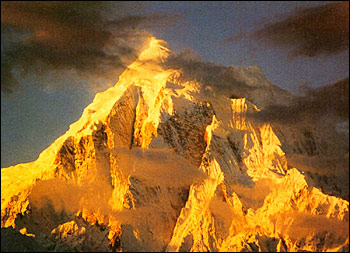
Mount Chogori, which in the Balti language (related to Tibetan) means "King of the Mountains," is also called K2 or Mount Godwin-Austen. Some 8,611 meters high in the Karakorum range on the China-Pakistan border, it is the second highest peak in the world. Chogori remains one of the most respected and feared mountains in the world, as it is harder to climb than Qomolangma. All attempts to reach its summit failed until an Italian expedition led by Dr. Ardito Desio did so in 1954. The area has more 7,000-meter-high peaks than any other single country, and includes five of the 13 8,000-meter-high peaks in the world.

Kangrinboqe Peak is the main peak of the Kangdese Mountains. About 6,714 meters above sea level, the mountain is powerful and imposing, holding a sacred position in many religions. For hundreds of years, Kangrinboqe has attracted numerous pilgrims and travelers with its many mystical stories and legends. Thousands of Chinese, overseas religious devotees, and tourists go there every year. Devout followers can take a year or longer to reach the sacred mountain, kowtowing all the way from afar.
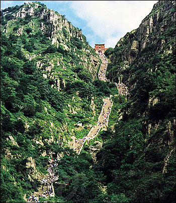
Mount Taishan is located in the central part of Shandong Province and is generally considered the most important of China's "Five Sacred Mountains." Standing between Jinan and Tai'an it covers a total area of 426 square kilometers. The main peak lies in Tai'an, 1,545 meters above sea level. Besides its wonderful natural landscapes, Mount Taishan was worshipped by emperors of different dynasties, and the only mountain qualified to accept the emperors' offerings. Eminent ancient scholars, masters and poets all yearned for it, including Confucius, Sima Qian, Li Bai and others, leaving plenty of cultural relics behind.

Mount Emei rises in the southwestern part of the Chengdu Plain in Emeishan City, with its highest peak at 3,099 meters above sea level. The craggy southern part of the mountain is crisscrossed by ravines and covered with a dense growth of plants, while the northern part features sheer precipices, and waterfalls cascading down the slope. Mount Emei is called the "Mountain of Brightness" in Buddhism. Legend goes that the Guangxiang Temple on the mountaintop was where the Goddess of Benevolence performed Buddhist rituals, thus making it one of the four famous sacred mountains of Buddhism in China. There used to be over 100 temples and halls on the mountain, but only some 20 still stand. The Baoguo Temple situated at the foot of the mountain is the largest temple on Mount Emei, built during the Ming Dynasty (1368-1644).
(China.org.cn by Zhang Rui, October 14, 2005)