
|
Location and Territory | Geographical Features | Natural Resources | Climate |
|
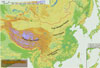
Four Major Plateaus |
|
|||||||||
|
|
|
 |
|
|
Qinghai-Tibet Plateau |
|
|
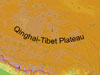 Situated
in southwest China, it is the largest plateau in China, covering 2.5 million
square km, or nearly a quarter of the national total land area. With an
elevation averaging between 3,000 and 5,000 meters, it is also the highest
plateau on earth, and is known as the "roof of the world." As it is surrounded
and traversed by several snow-capped mountain ranges, like the Kunlunshan,
Qilianshan, Hengduanshan and the Himalayas, which abound in glacier, the
Qinghai-Tibet Plateau is where many of China's major rivers originate. Situated
in southwest China, it is the largest plateau in China, covering 2.5 million
square km, or nearly a quarter of the national total land area. With an
elevation averaging between 3,000 and 5,000 meters, it is also the highest
plateau on earth, and is known as the "roof of the world." As it is surrounded
and traversed by several snow-capped mountain ranges, like the Kunlunshan,
Qilianshan, Hengduanshan and the Himalayas, which abound in glacier, the
Qinghai-Tibet Plateau is where many of China's major rivers originate. |
|
|
Inner Mongolia Plateau |
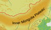 The
second largest plateau in China, it lies between 1,000 and 1,500 meters
above sea level in north China. Covering 700,000 square km, the plateau
has a gentle rolling terrain and vast grasslands, with some parts covered
with arid Gobi and deserts. The
second largest plateau in China, it lies between 1,000 and 1,500 meters
above sea level in north China. Covering 700,000 square km, the plateau
has a gentle rolling terrain and vast grasslands, with some parts covered
with arid Gobi and deserts.
|
||
|
Loess Plateau |
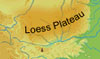 With
the Taihangshan Mountains to its east, the Qilianshan Mountains to its west,
the Great Wall to its north and the Qinling Mountains to its south, the
Loess Plateau covers around 500,000 square km and lies 1,000 to 2,000 meters
above sea level. Covered with thick, porous loess, the plateau is crisscrossed
with ravines and gullies, and has fragmented landforms due to long-term
scouring of rainfall and streams. Water eroded area accounts for 430,000
square km. With
the Taihangshan Mountains to its east, the Qilianshan Mountains to its west,
the Great Wall to its north and the Qinling Mountains to its south, the
Loess Plateau covers around 500,000 square km and lies 1,000 to 2,000 meters
above sea level. Covered with thick, porous loess, the plateau is crisscrossed
with ravines and gullies, and has fragmented landforms due to long-term
scouring of rainfall and streams. Water eroded area accounts for 430,000
square km. |
||
|
Yunnan-Guizhou Plateau |
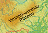 Covering
500,000 square km, it comprises east Yunnan Province and most parts of Guizhou
Province. It has an elevation of 1,000 to 2,000 meters and a terrain that
descends from northwest to southeast. It is covered with numerous mountain
ridges, valleys and rugged landforms. There are some small basins in mountains,
with concentrated population and developed agriculture. Covering
500,000 square km, it comprises east Yunnan Province and most parts of Guizhou
Province. It has an elevation of 1,000 to 2,000 meters and a terrain that
descends from northwest to southeast. It is covered with numerous mountain
ridges, valleys and rugged landforms. There are some small basins in mountains,
with concentrated population and developed agriculture. |
||