|
Location and Territory | Geographical Features | Natural Resources | Climate |
|
Plains |
|
|||||||||
|
|
|
|
|
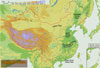
Northeast China Plain |
|
|
 Situated
in northeast China, the plain lies between the Greater and Lesser Hinggan
and Changbaishan mountains. Covering 350,000 square km, it is China's largest
plain. With most of it having an elevation of lower than 200 meters, it
embodies the Songhuajiang-Nenjiang-Heilongjiang Plain, Songliao Plain and
Liaohe Plain. Situated
in northeast China, the plain lies between the Greater and Lesser Hinggan
and Changbaishan mountains. Covering 350,000 square km, it is China's largest
plain. With most of it having an elevation of lower than 200 meters, it
embodies the Songhuajiang-Nenjiang-Heilongjiang Plain, Songliao Plain and
Liaohe Plain. |
|
|
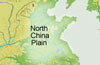
North China Plain |
|
|
||
|
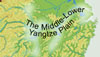
The Middle-Lower Yangtze Plain |
|
|
||
|
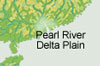
Pearl River Delta Plain |
|
|
||
|
Hetao Plain |
|
|
||