China abounds in rivers, lakes and water resources.
Due to its topographical
features, most rivers flow east or south into the ocean, thus forming
vast outflow river valleys that constitute nearly two-thirds of the
national total area. Most of them belong to the Pacific Valley and a
small number fall into the Indian Ocean Valley. Only the Erix River
in the Xinjiang Uygur Autonomous Region that flows westerly out of China
belongs to the Arctic Ocean Valley.
More than 1,500 rivers have a drainage area of over 1,000 square km.
The average annual runoff stands at 2.7 trillion cubic meters, ranking
sixth in the world. Holding the top five positions are Brazil, Russia,
Canada, the United States and Indonesia. Famous rivers in China include
the Yangtze River, the Yellow River, the Heilongjiang River, the Yarlung
Zangbo River, the Pearl River and the Huaihe River. The Tarim River
in Xinjiang is the longest inland river in China. This 2,100-km-long
river has been known as the "river of life," as it runs across deserts.
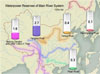
Because most of the main rivers originate from the Qinghai-Tibet Plateau
with big falls, China has abundant waterpower resources, with total
reserves of 680 million kw, ranking first in the world. However, the
waterpower resources are unevenly distributed, with 70 percent in southwest
China. The Yangtze River system has the most waterpower resources, which
account for nearly 40 percent of the national total, followed by the
Yarlung Zangbo River system. The Yellow and Pearl river systems also
abound in waterpower resources.
Waterpower Reserves of Main River System
River system |
Waterpower reserves (100m kw)
|
Proportion (%) |
| National total |
6.8 |
100% |
| Yangtze River |
2.7 |
40% |
| Yellow River |
0.4 |
0.6% |
| Pearl River |
0.3 |
0.4% |
| Heilongjiang River |
0.1 |
0.1% |
| Yarlung Zangbo and other rivers in Tibet |
1.6 |
24% |