Location and Territory  Geographical Features   |  Natural Resources   |   Climate

Main Mountain Ranges


Four Major Plateaus
  Basins Plains
  Rivers, Lakes and Water Resources

Rivers, Lakes and Water Resources

Water Resources
Main Rivers
Lakes  

Yangtze River


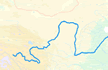
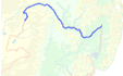
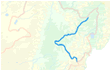
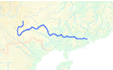
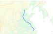
The largest in China and the third longest in the world, the Yangtze rises in Geladaindong, the highest peak of the Tanggulashan Mountains. It flows 6,300 km eastward traversing 11 provinces, autonomous regions and municipalities before emptying into the East China Sea. It has numerous tributaries, including the Yalongjiang, Minjiang, Jialingjiang, Hanjiang, Wujiang, Xiangjiang and Ganjiang rivers, with a combined drainage area of over 1.8 million square km, accounting for 18.8 percent of China's total area. Its annual runoff stands at 951.3 billion cubic meters, accounting for 52 percent of the national total. It is a major artery of inland water transportation in China.

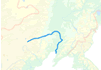
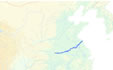
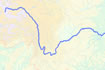
Flowing easterly from Fengjie County, Chongqing Municipality, to Yichang City, Hubei Province, the Yangtze cuts across Wushan Mountain, forming three gorges with a total length of 193 km. The famous Three Gorges Water Project began construction at the eastern section of the area in 1994. After completion in 2009, the project is expected to be able to control catastrophic flooding in nearby drainage areas that occurs once in a century. It is also expected to annually generate 84.7 billion kwh of electricity, improve navigation conditions, and ensure water supply in urban areas and irrigation of farmland in the middle and lower reaches of the Yangtze River.


Yellow River


The second largest in China, it originates from the northern foot of Bayan Har Mountain in Qinghai Province. It flows 5,464 km easterly across nine provinces and autonomous regions before emptying into the Bohai Sea. With a drainage area of more than 750,000 square km, its annual runoff is 66.1 billion cubic meters. It has more than 40 tributaries, of which Fenhe and Weihe rivers are the main ones.

The middle section of the river traverses the Loess Plateau with loose soils, making it a river with highest silt content in the world. Around a quarter of the total silt it carries is deposited at downstream riverbeds, making them rise 10 cm a year on average. Thus, the riverbed of many downstream sections of the river is 3 to 5 meters higher than the surrounding land.

The upstream of the Yellow River runs through the junction of the country's first- and second-terrace regions, a section reserving most waterpower resources of the river. Many water conservancy projects have been built in this area, including those at Longyangxia, Liujiaxia and Qingtongxia. The middle reaches of the river also abound in waterpower resources. The Xiaolangdi Water Project, situated in Henan Province, is under construction.


 Heilongjiang River


Situated in the northernmost part of China, it is the boundary river between China and Russia. Its mainstream flows 3,420 km within the boundaries of China, with a drainage area of around 900,000 square km.


Songhuajiang River


It flows 2,308 km, with a drainage area of 557,180 square km and an annual runoff of 76.2 billion cubic meters.。


 Liaohe River


It flows 1,390 km, with a drainage area of 228,900 square km and an annual runoff of 14.8 billion cubic meters.


Pearl River


The largest in south China, it flows 2,214 km, with a drainage area of 453,690 square km and an annual runoff of 333.8 billion cubic meters. In terms of runoff volume, it is considered the second largest in China, next to the Yangtze River.


Huaihe River


It flows 1,000 km, with a drainage area of 269,283 square km and an annual runoff of 62.2 billion cubic meters.


 Beijing-Hangzhou Grand Canal


Starting from Beijing's Tongzhou District in the north, the canal extends 1,800 km to Hangzhou, Zhejiang Province in the south. Flowing through Beijing, Tianjin, Hebei, Shandong, Jiangsu and Zhejiang, it connects the Haihe, Yellow, Huaihe, Yangtze and Qiantangjiang rivers. First dug in the fifth century B.C., the canal served as an important channel for the transport of grain in ancient China. The earliest and longest artificial waterway in the world, its southern section is still navigable.